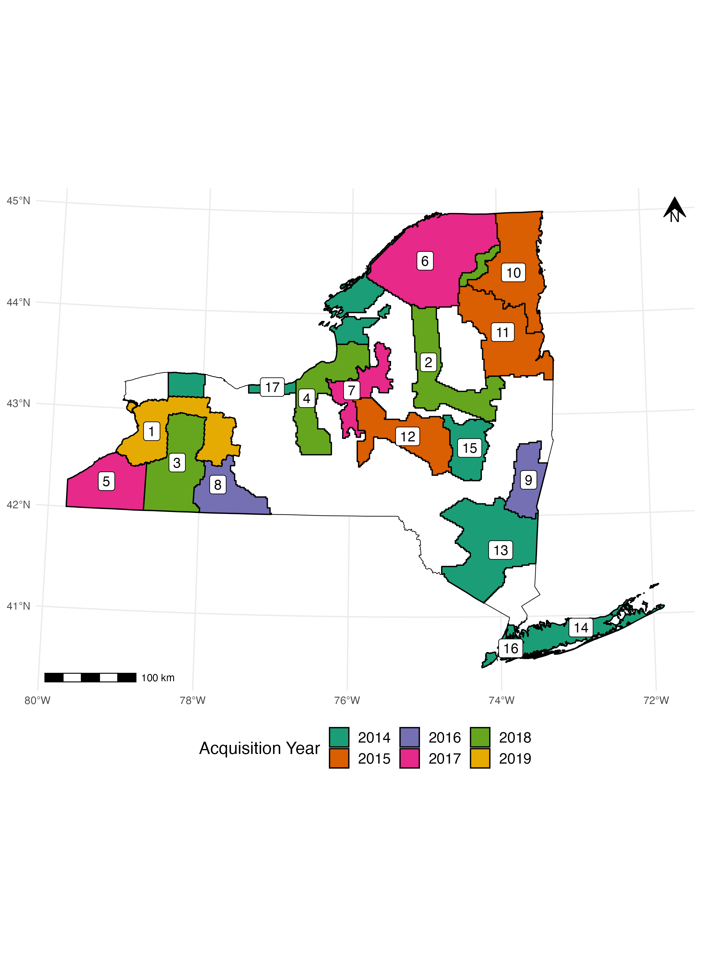
Acceptable Growing Stock
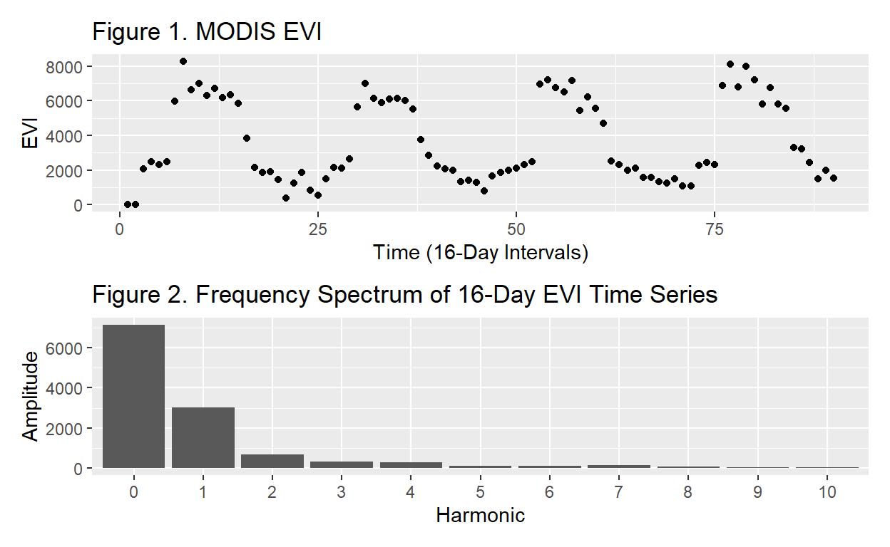
Fourier Series Phenometrics
Deriving phenological metrics from Fourier analysis of time series data.
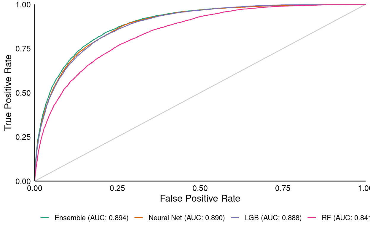
GNN SPP Fourier
Modeling Species Composition with GNN and Fourier Phenometrics
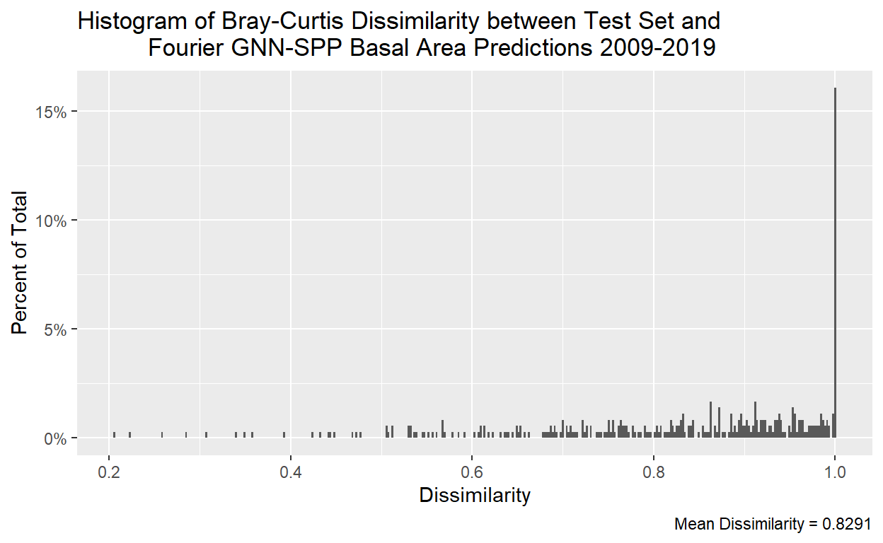
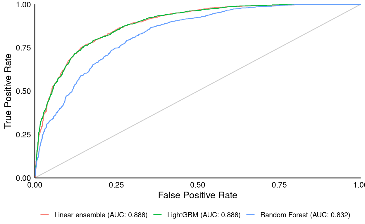
GNN-SPP Rank Correlation
Assessing GNN-SPP Accuracy by Rank Correlation
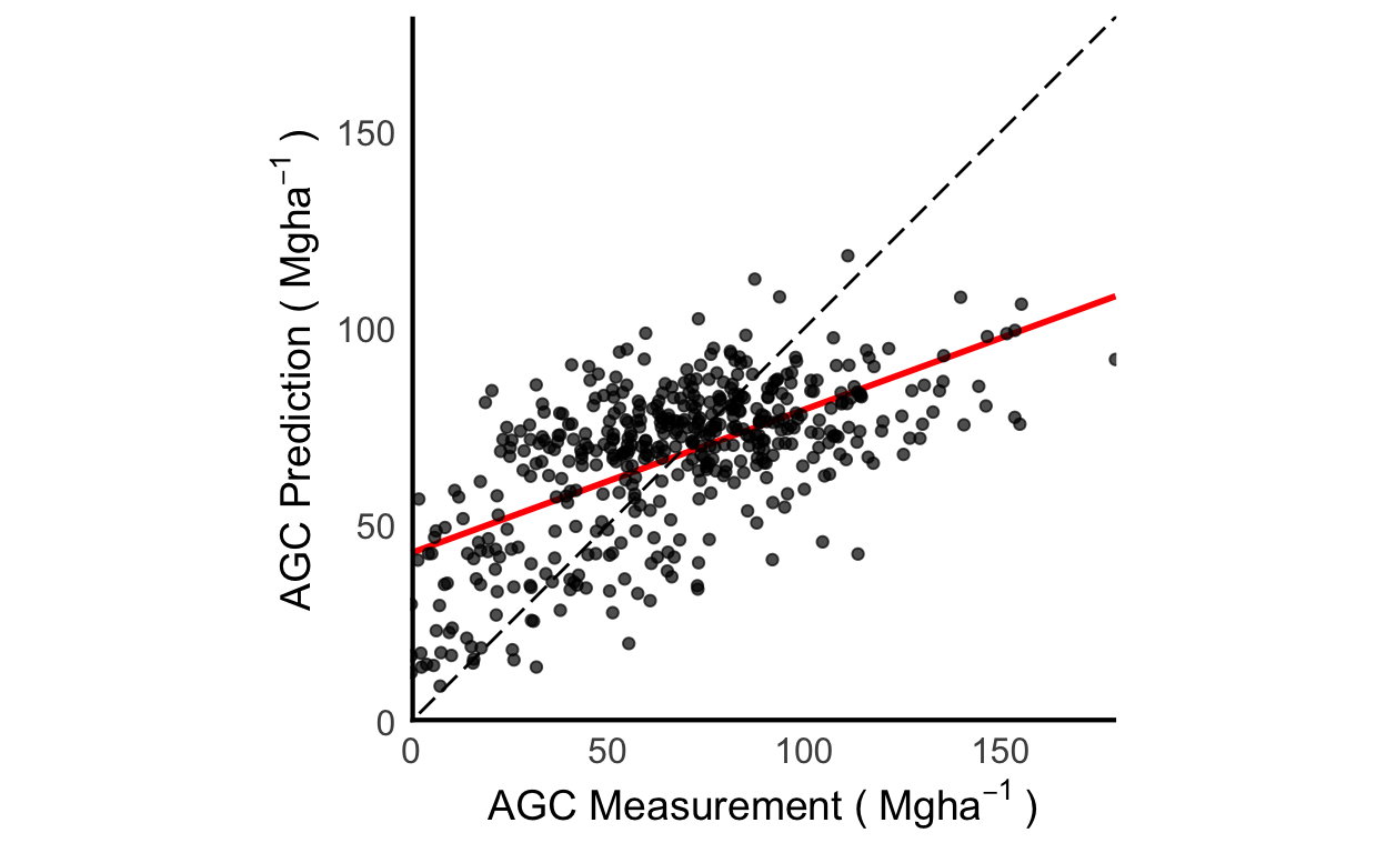
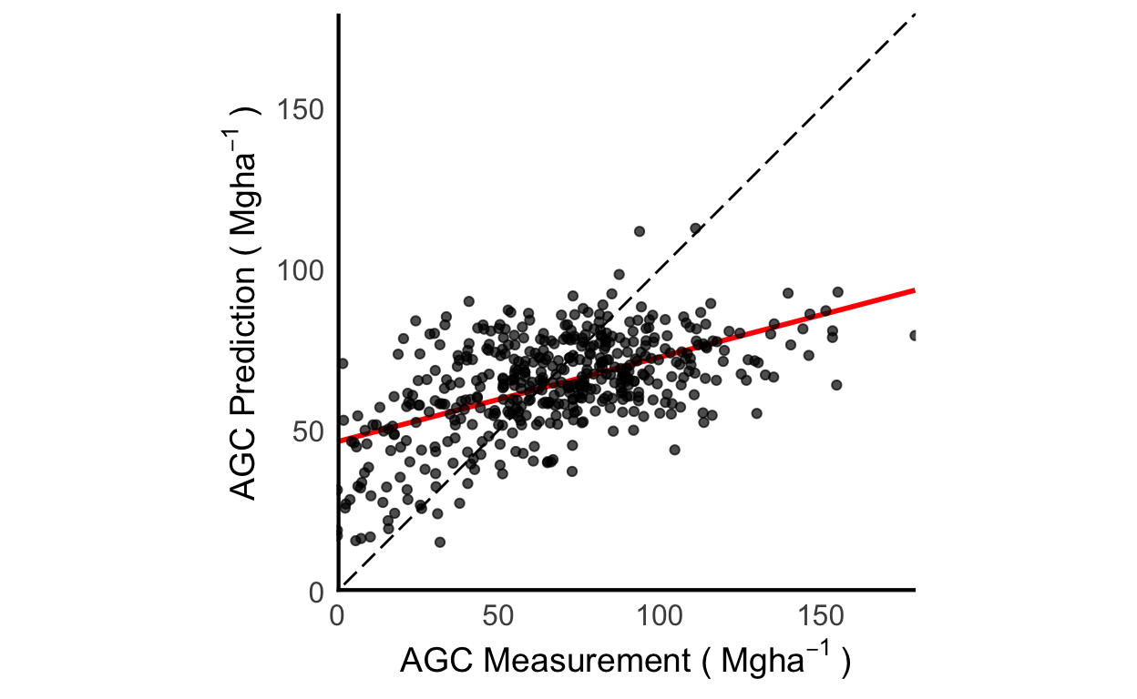
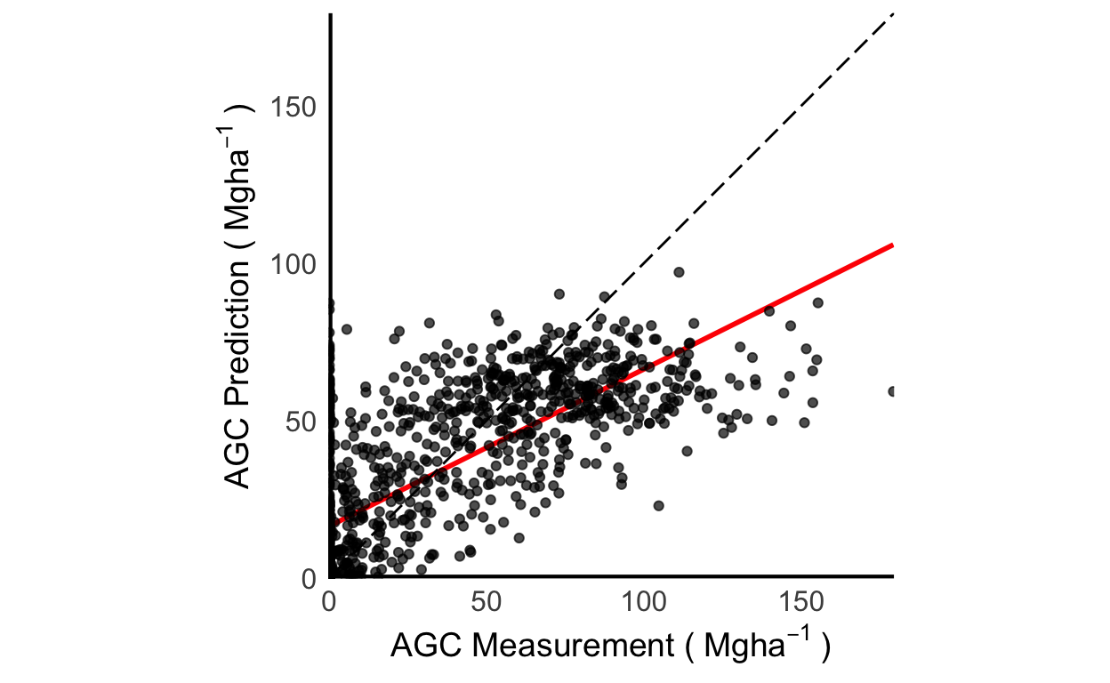
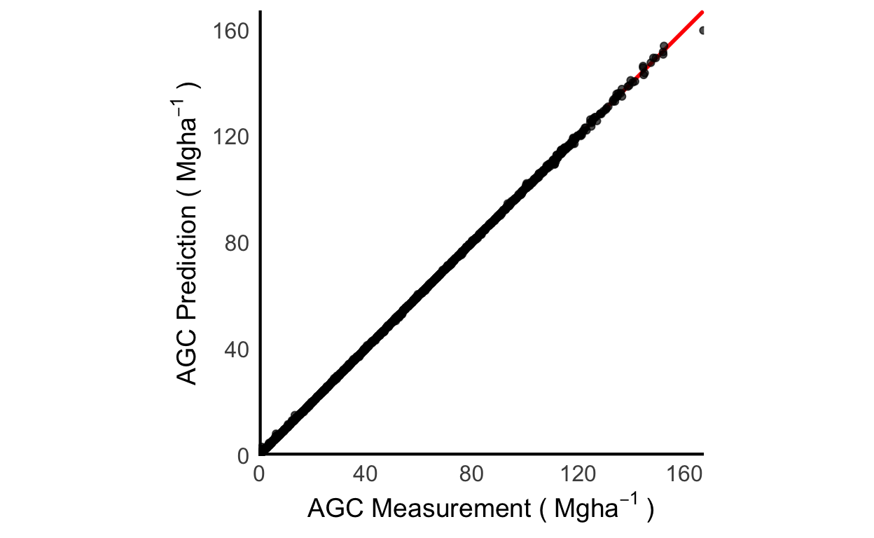
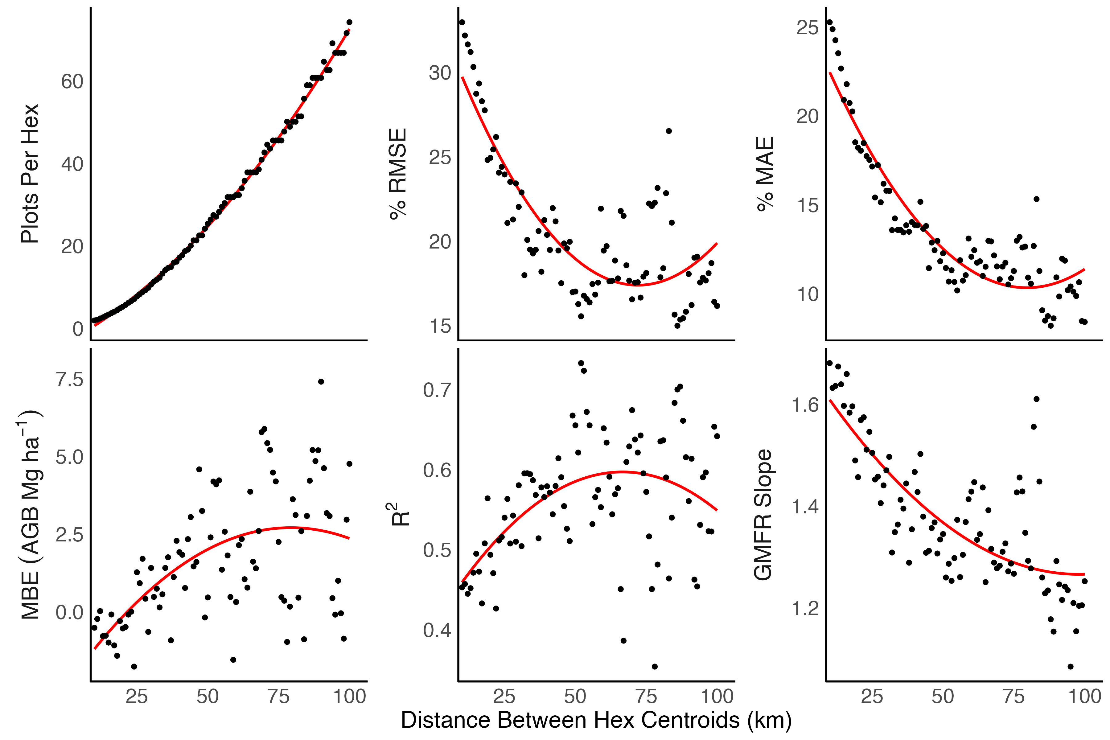
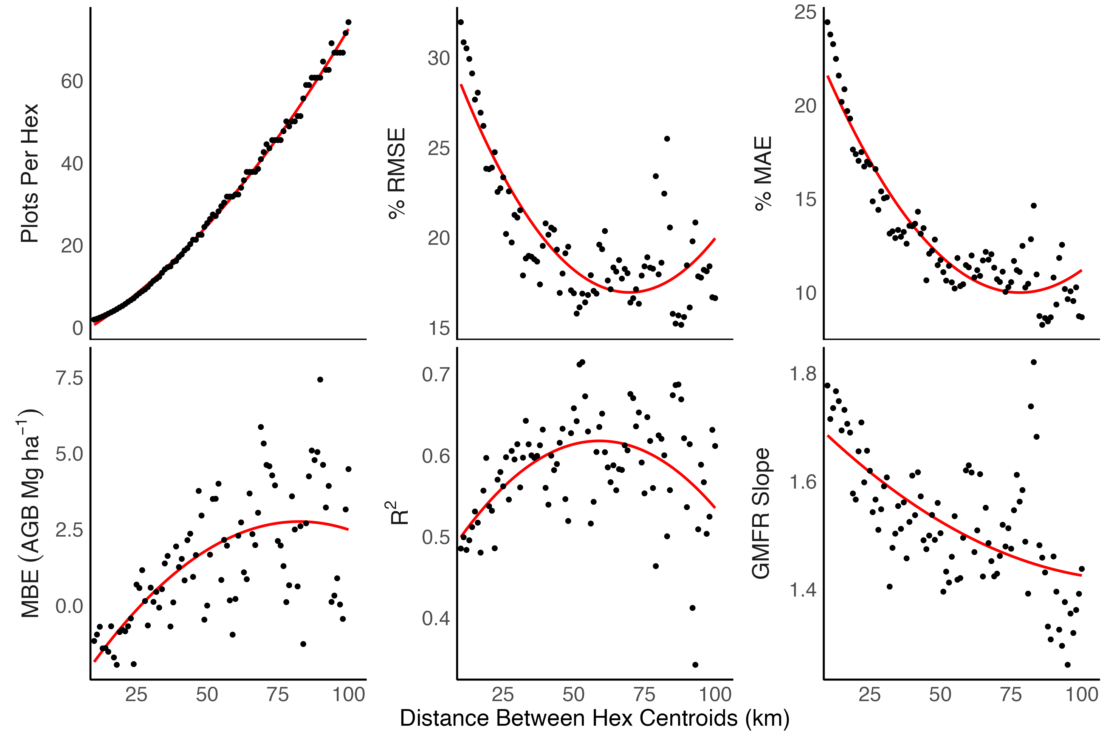
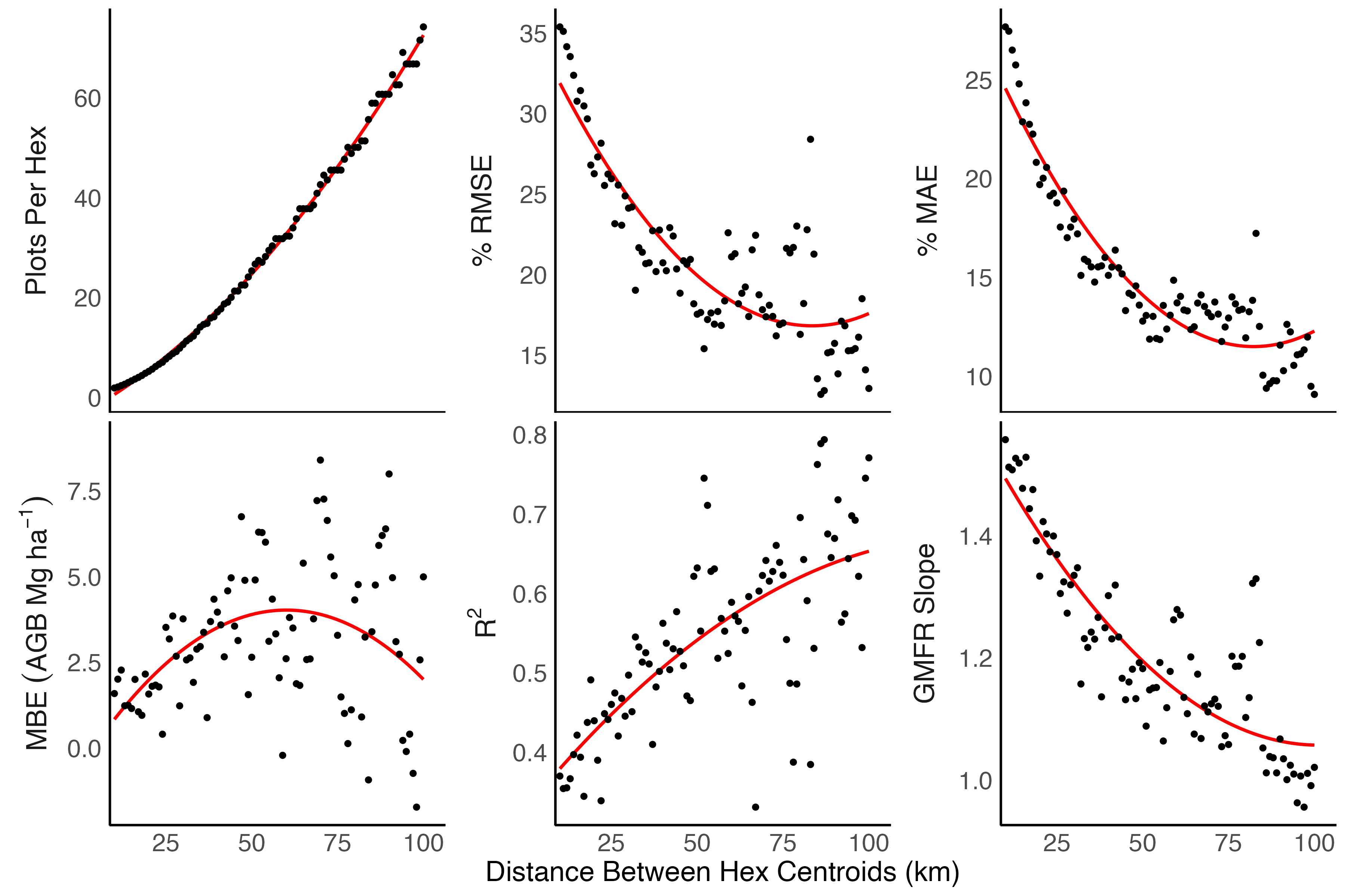
Landsat-AGB 1.2.0
Description of changes to Landsat-AGB modeling included in v1.2.0 developed in the Landsat-AGB manuscript.
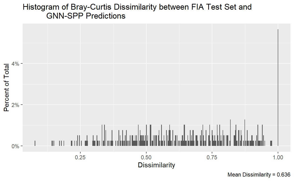
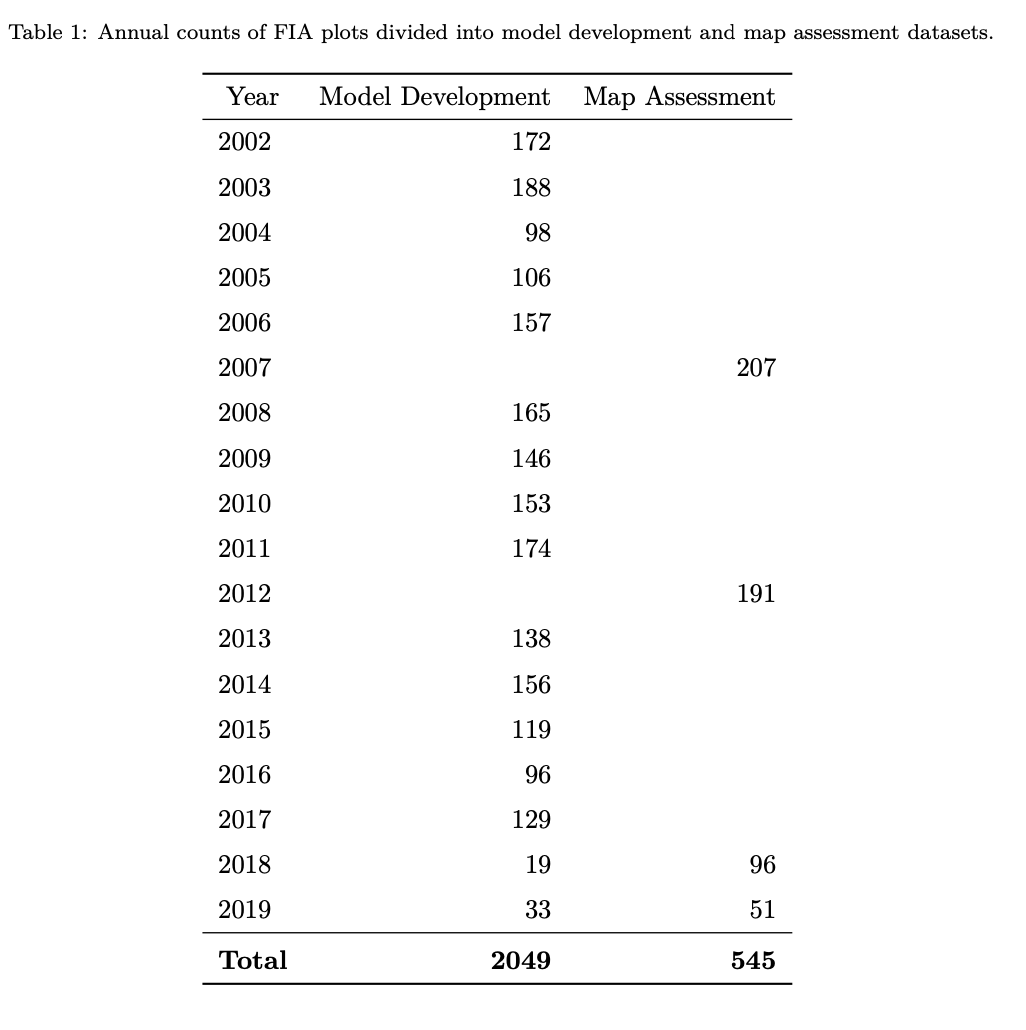
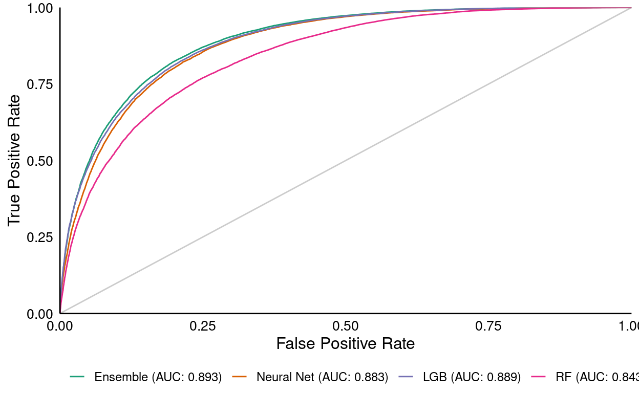
GNN-SPP 0.0.1
Modeling tree species composition with GNN.
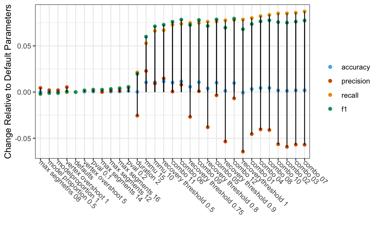
LT Tuning: Round 1 & 1.5
Summary of intial tuning results for the Landtrendr algorithm, plus bonus results from tunings using the multiple disturbance accuracy assesment protocol.
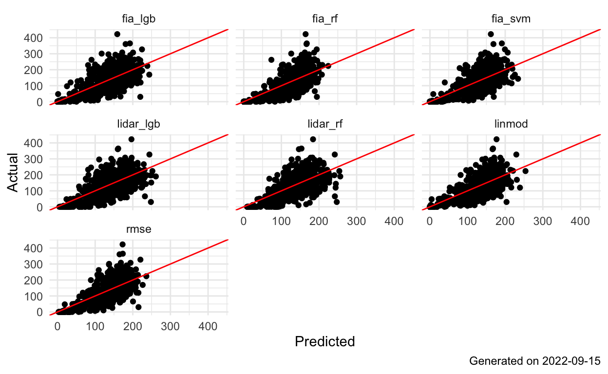
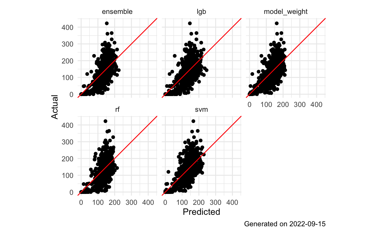
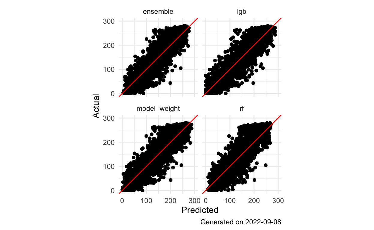
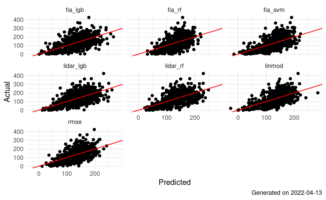
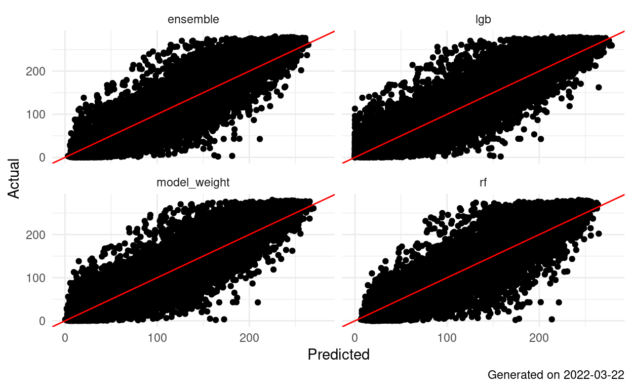
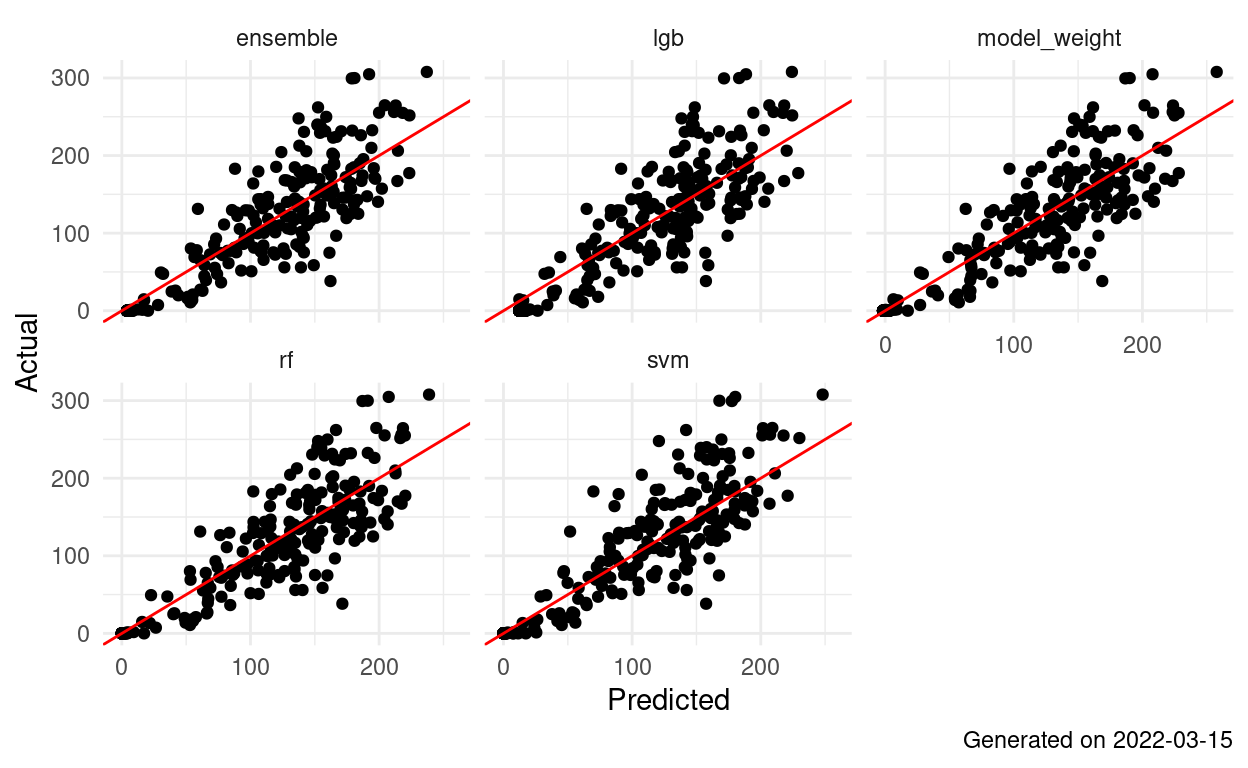
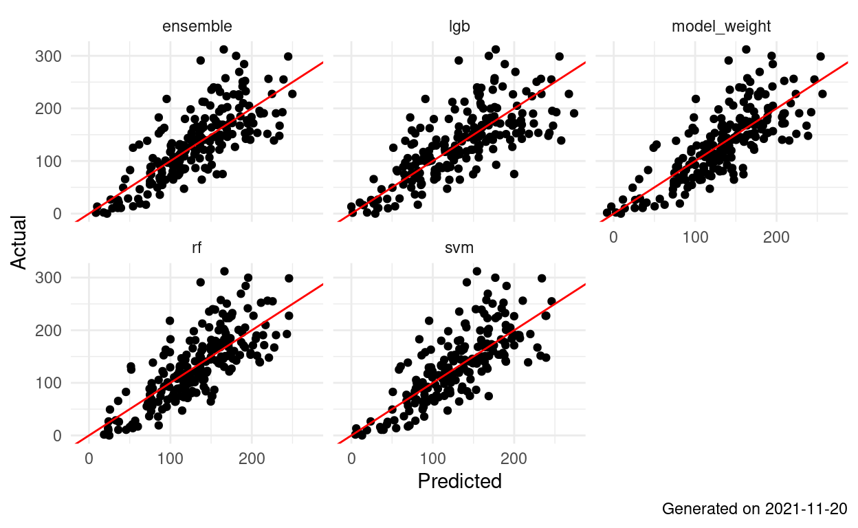
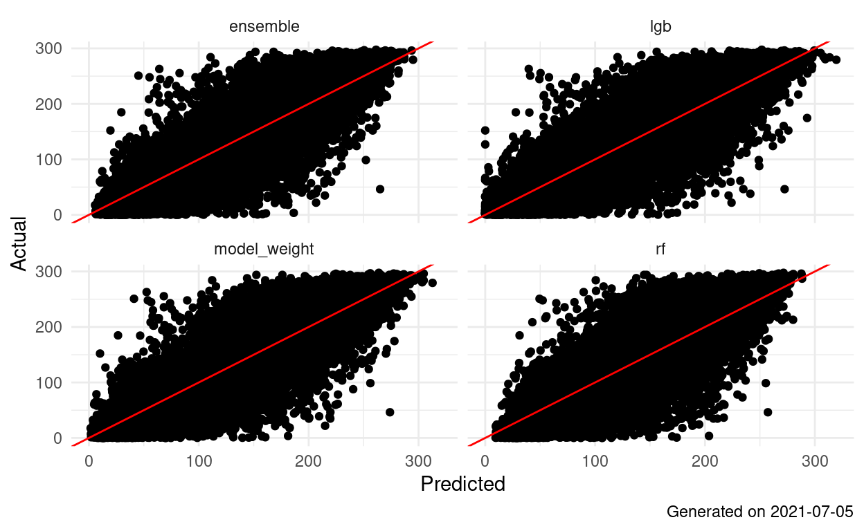
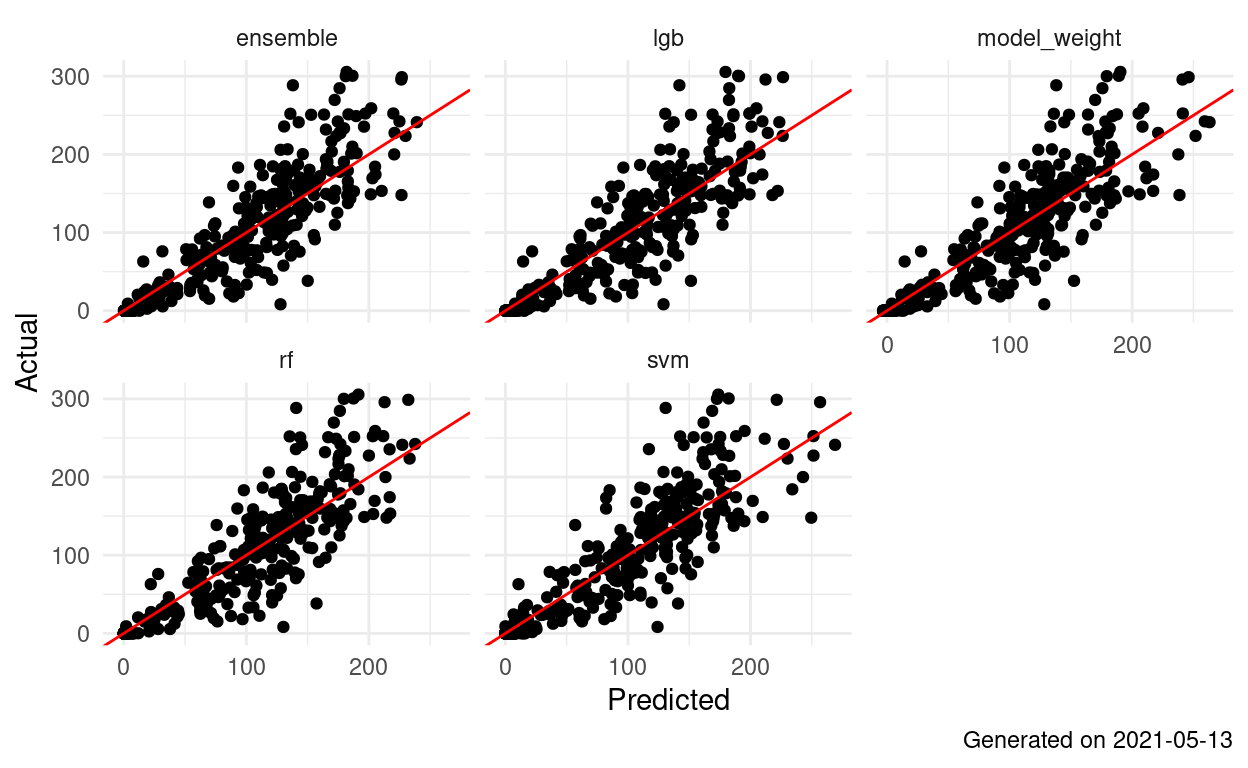
Landsat Ensemble AGB 1.1.1: Data Ensemble
Landsat:LiDAR AGB 1.1.2 PCA (less data more faster)
Landsat FIA AGB 1.1.3: Stratified Sample
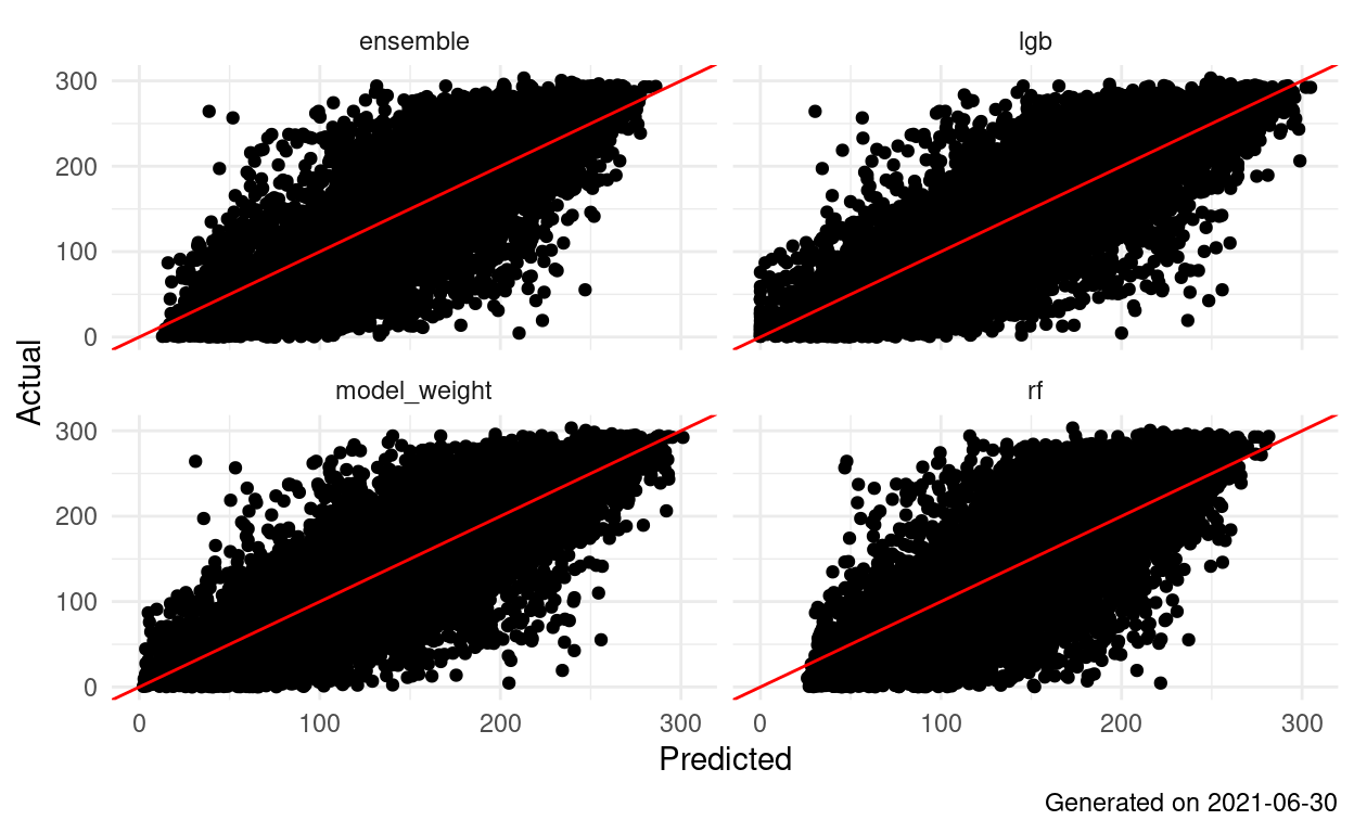
Landsat Ensemble AGB 1.1.0: More Data = More Better
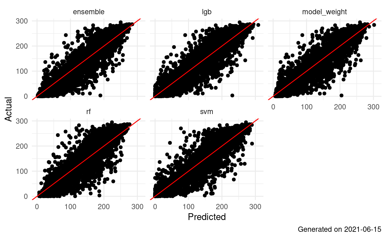
Landsat FIA AGB 1.1.2: PCA (less data = more faster
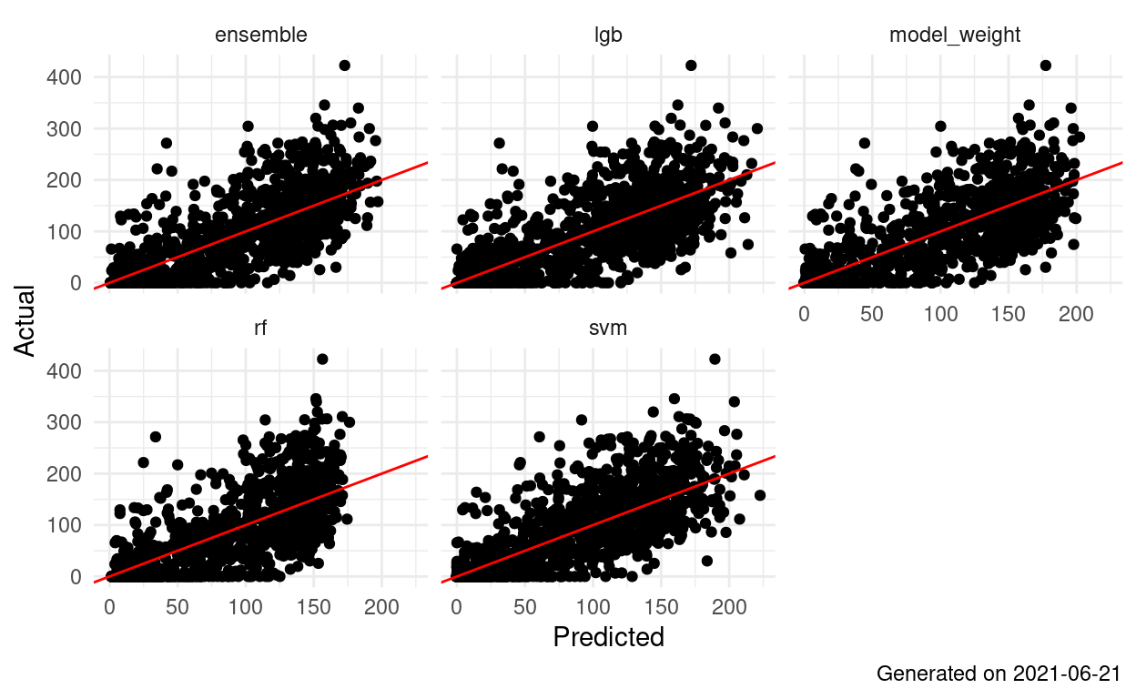
Landsat:LiDAR AGB 1.1.0 More data = more better
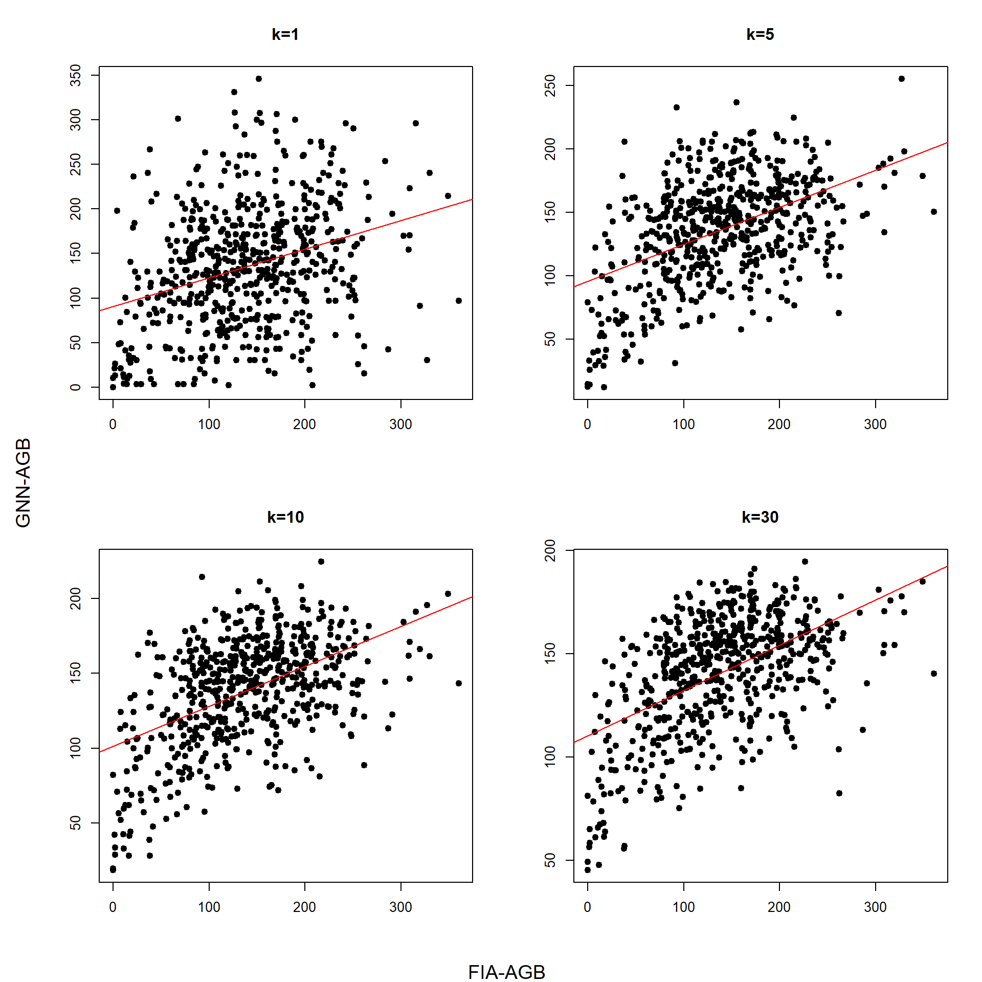
GNN-AGB 0.0.1
Modeling aboveground biomass from geospatial and FIA field data with the Gradient Nearest Neighbor (GNN) method.
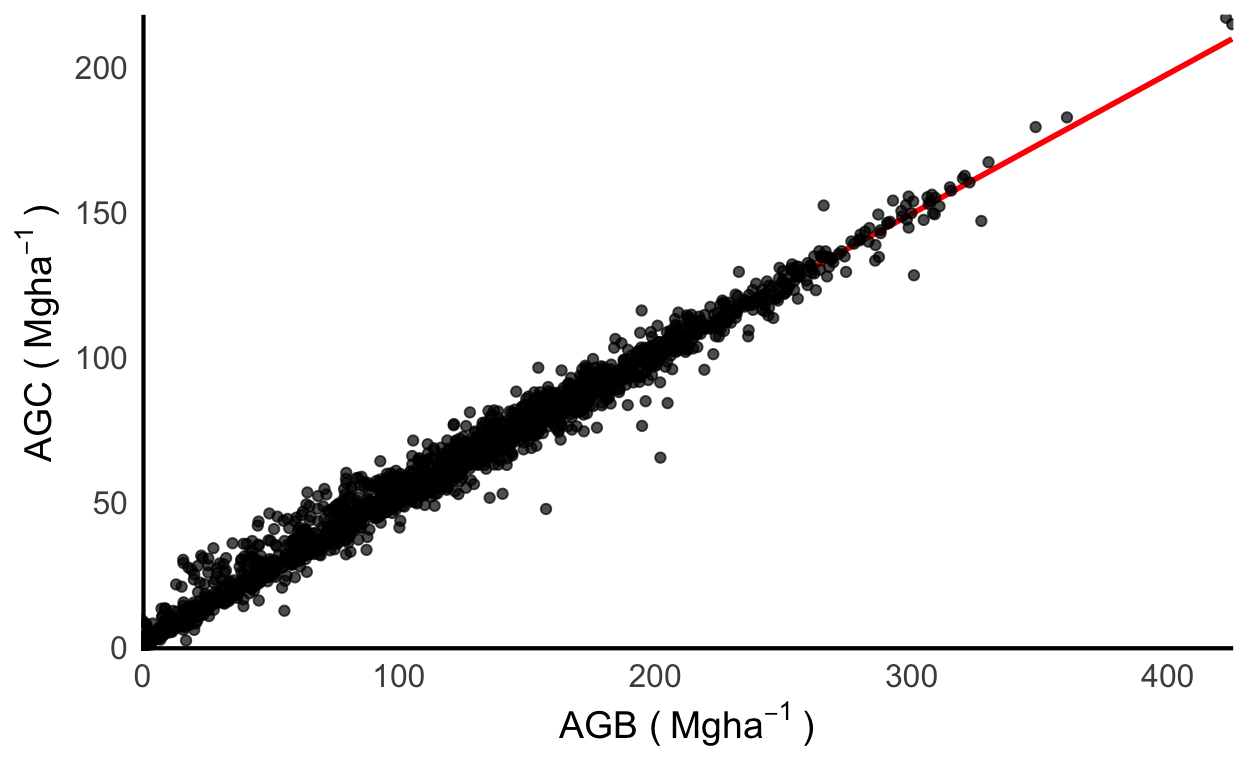
Carbon Conversion - Take 4: Forest Only
Modeling forest carbon pools as a function of aboveground biomass and static climate and topographic predictors.
Carbon Conversion - Take 4b: True AGB
Modeling forest carbon pools as a function of aboveground biomass and static climate and topographic predictors.
Carbon Conversion - Take 3: CAFRI-AGB Training
Modeling forest carbon pools as a function of aboveground biomass and static climate and topographic predictors.
Carbon Conversion - Take 2: Plot Measurements
Modeling forest carbon pools as a function of aboveground biomass and static climate and topographic predictors.

Landsat FIA AGB 1.1.1: LiDAR Zeros

Landsat FIA AGB 1.1.0: More data = more better
Landsat Ensemble v1.0.0 Map Accuracy
Map accuracy/agreement assessment following the Riemann et. al. framework.
Landsat:FIA-AGB v0.0.99 Map Accuracy
Map accuracy/agreement assessment following the Riemann et. al. framework.
Landsat:LiDAR-AGB v0.0.99 Map Accuracy
Map accuracy/agreement assessment following the Riemann et. al. framework.
Carbon Conversion - Take 1
Modeling forest carbon pools as a function of aboveground biomass.
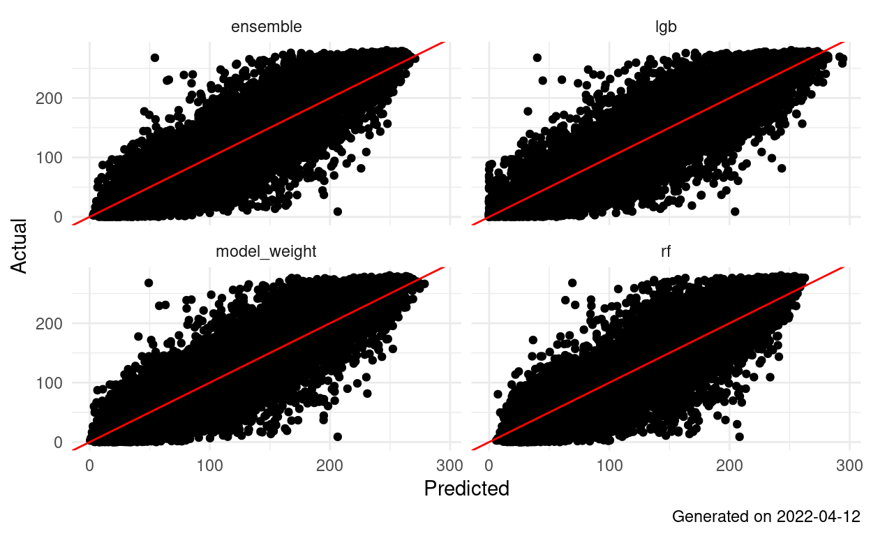
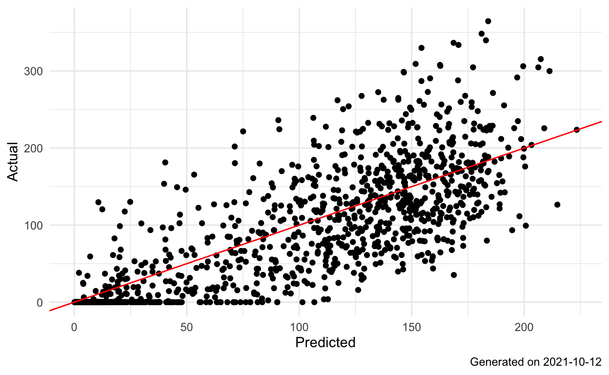
Landsat AGB 1.0.0: One Ensemble to Rule Them All
Landsat:LiDAR AGB 0.0.99: Final Countdown
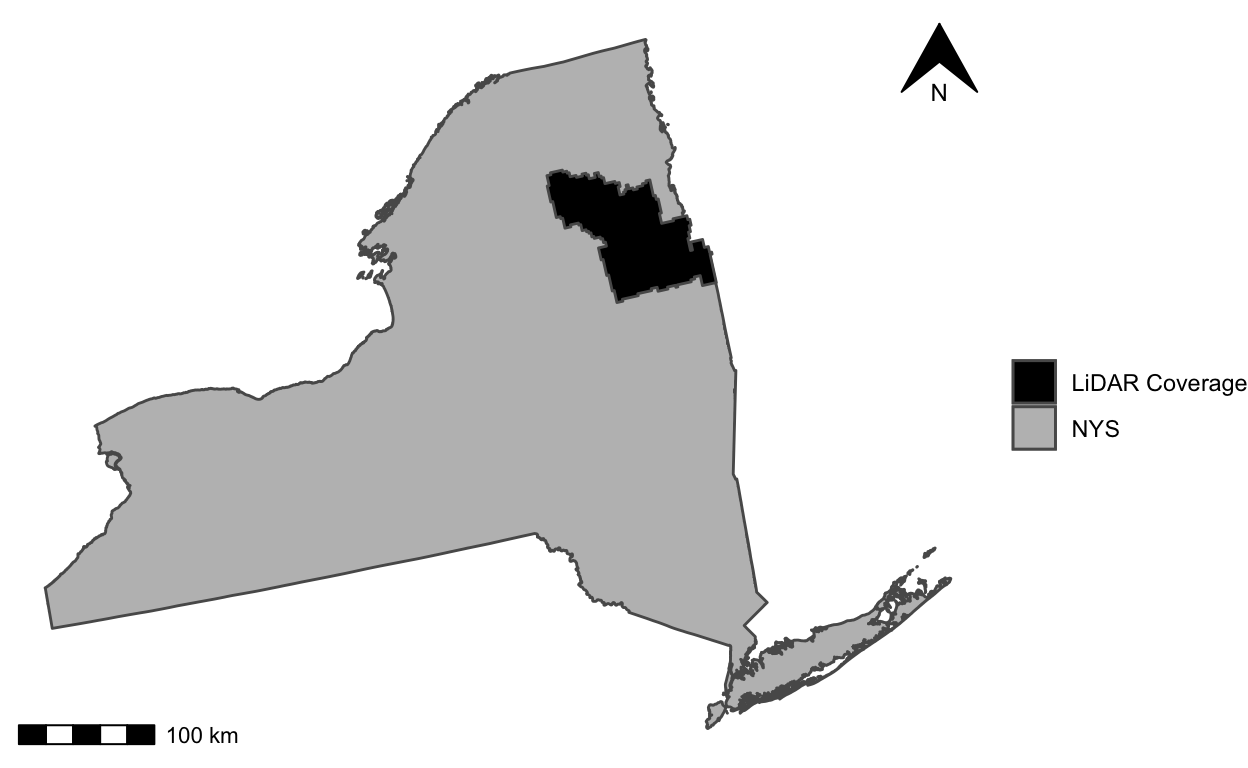
Hudak-method models using LiDAR surfaces masked by both LCMAP and AOA. 2022-04-12
Landsat FIA AGB 0.0.99: Final Countdown
Landsat:LiDAR-AGB v0.0.8 Map Accuracy
Map accuracy/agreement assessment following the Riemann et. al. framework.
Landsat:LiDAR AGB 0.0.8: Another One
Hudak-method models using LiDAR surfaces masked by both LCMAP and AOA. 2022-03-22
LiDAR-AGB Draft Tables and Figures
Building blocks for the LiDAR-AGB manuscript...
1.4.0: A Little Adjustment
Lidar-based models adding 0 AGB with low-LiDAR back in to the mix
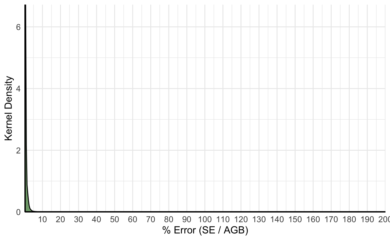
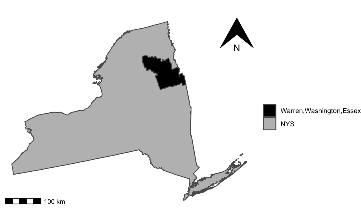
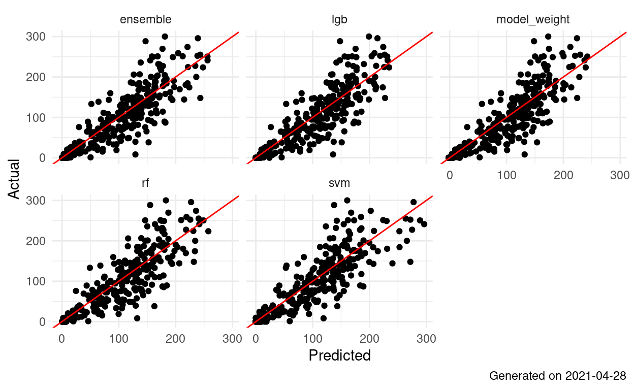
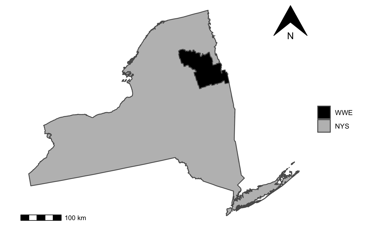
Model Bootstrap Uncertainty Estimates for Tax Parcels in WWE
Proof-of-concept analytical estimates of standard error for AGB predictions aggregated within 2019 NYS tax parcels in the Warren, Washington, Essex LiDAR coverage
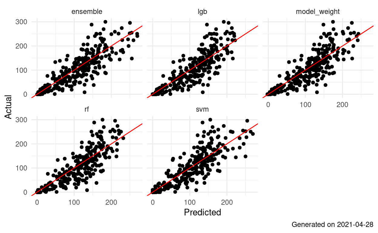
Analytical Uncertainty Estimates for Tax Parcels in WWE
Proof-of-concept analytical estimates of standard error for AGB predictions aggregated within 2019 NYS tax parcels in the Warren, Washington, Essex LiDAR coverage
Bounded Normal Residuals - Model Based Error for Tax Parcels in WWE
Proof-of-concept model-based error estimates for AGB predictions aggregated within 2019 NYS tax parcels in the Warren, Washington, Essex LiDAR coverage. Residuals sampled from a normal distribution centered on predictions, bounded by 95% conformal bounds.
First draft of graphics and tables for ground filtering paper
A living document with set pieces for the ground filtering paper.
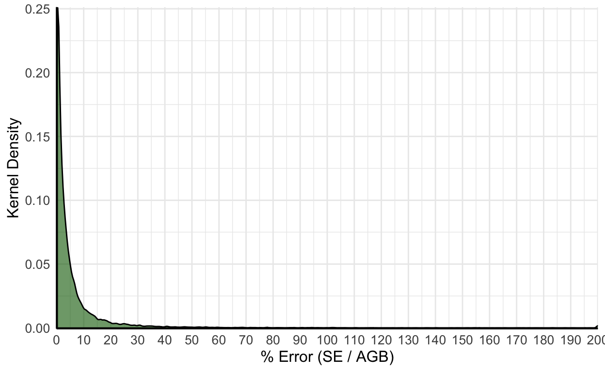
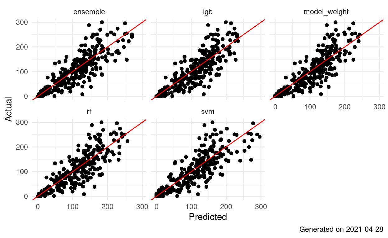
Model Based Error for Tax Parcels in WWE
Proof-of-concept model-based error estimates for AGB predictions aggregated within 2019 NYS tax parcels in the Warren, Washington, Essex LiDAR coverage
Uncertainty Estimates for Tax Parcels in WWE
Proof-of-concept bootstrap estimates of standard error for AGB predictions aggregated within 2019 NYS tax parcels in the Warren, Washington, Essex LiDAR coverage
NYS Tax Parcel Sizes
2019 NYS tax parcel size summary by ownership and use.
First draft of graphics and tables for shrubland paper
A living document with set pieces for the shrubland paper.
Shrubland 1.0.2: Statewide Prediction Accuracy
Applying 2022-01-21 shrubland models to all lidar coverages.
Shrubland 1.0.2: Balanced Diet
Re-doing the supersized models with a balanced sample. 2022-01-21
Shrubland 1.0.1: Statewide Prediction Accuracy
Applying 2022-01-16 shrubland models to all lidar coverages.
Shrubland 1.0.1: Supersize Me
The first iteration of shrubland model reporting. 2022-01-16
Shrubland 1.0: Statewide Prediction Accuracy
Applying 2022-01-15 shrubland models to all lidar coverages.

Shrubland 1.0: The Gang's All Here
Including a neural net in the shrubland ensemble. 2022-01-15
Shrubland 0.0.1: Making It Happen
The first iteration of shrubland model reporting. 2022-01-12
Statewide Shrubland Prediction Accuracy
Applying 2022-01-12 shrubland models to all lidar coverages.

LiDAR x Stem Inclusion & Forest Conditions
Comparisons of FIA reference datasets for LiDAR-AGB modeling based on various stem inclusion and forest condition rules
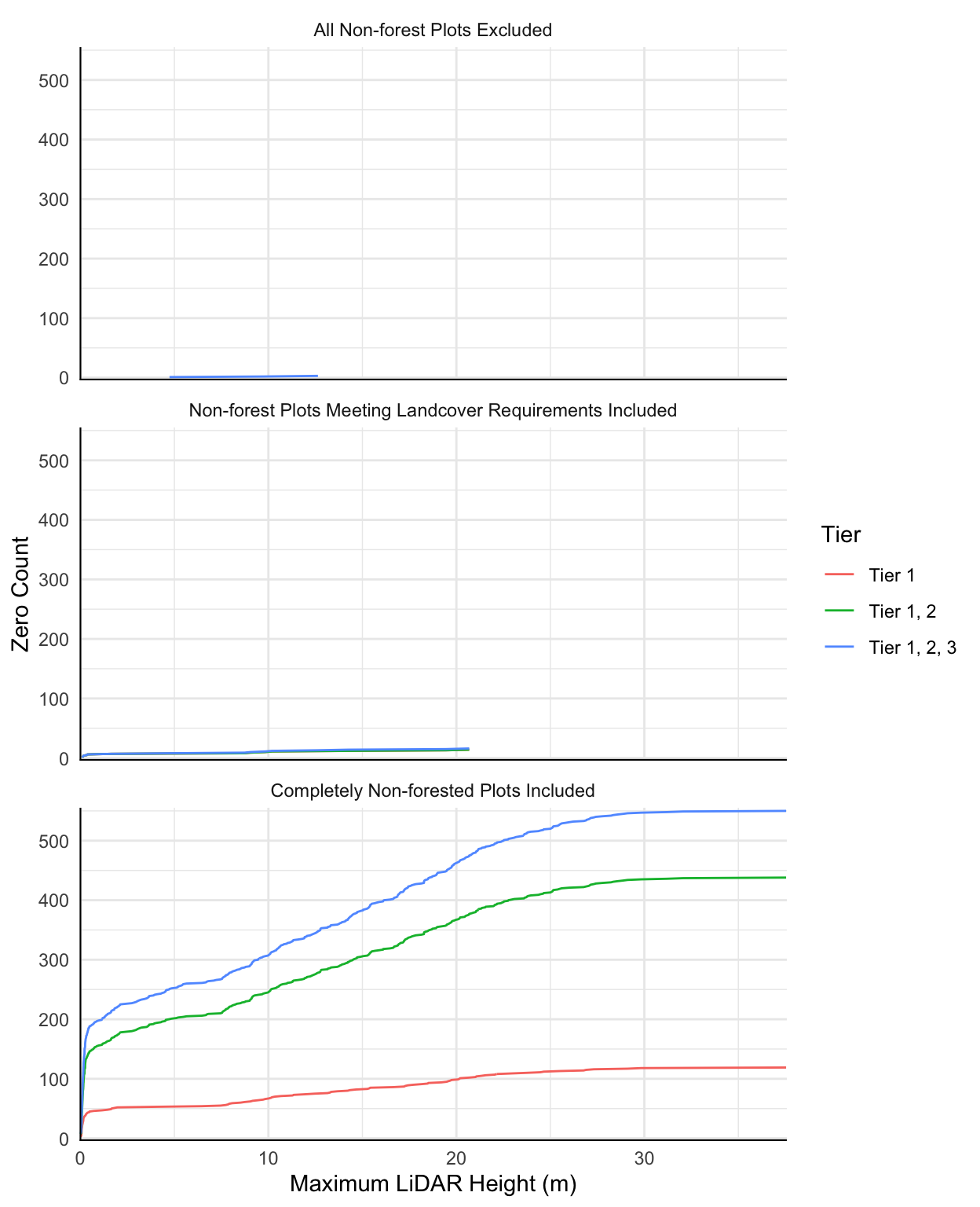
LiDAR x Non-forest Plots
Comparisons of FIA reference datasets for LiDAR-AGB modeling based on various non-forest plot inclusion rules.
1.3.0: Seeing the (Non)Forest (Out, because it's not measured)
Lidar-based models removing all plots with non-forest inclusions
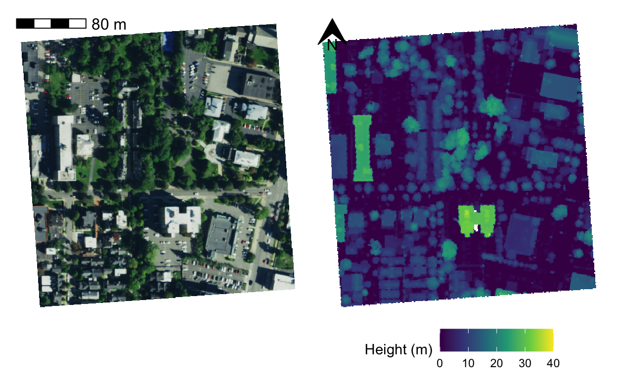
NAIP imagery and LiDAR CHMs
Samples of potential input data for the detectreeRGB tree crown delination algorithm.
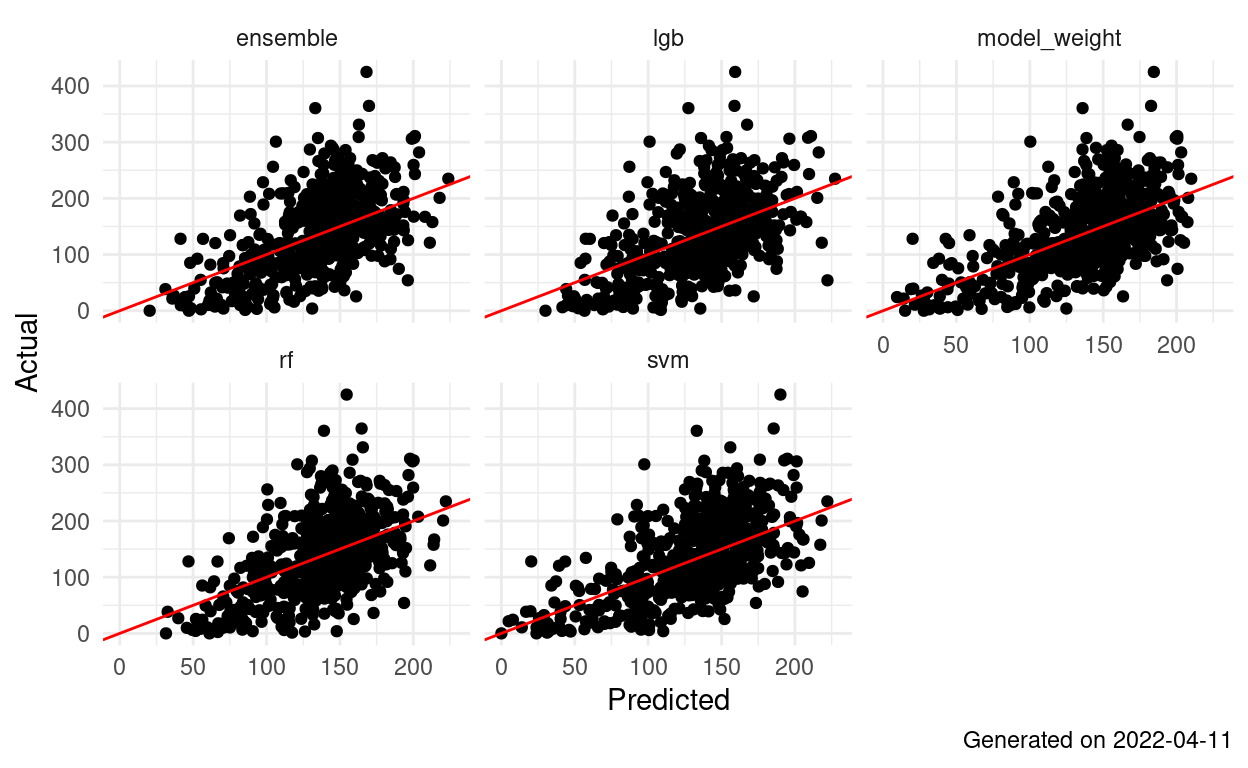
Landsat Ensemble 1.0: LCMAP-RMSE Weighted
RMSE weighted ensemble of LINMOD models from Landsat:LiDAR-AGB 0.0.7 and Landsat:FIA 0.0.5
Landsat Ensemble v1.0 Map Accuracy
Map accuracy/agreement assessment following the Riemann et. al. framework.
Landsat Modeling Comparison
Comparison of best Landsat:FIA modeling approach to five Landsat:LiDAR approaches. Results extracted from individual model docs and summarized here.
Landsat:LiDAR-AGB v0.0.7 Map Accuracy
Map accuracy/agreement assessment following the Riemann et. al. framework.
WWE AGB - Mann-Kendall + Sen's slope
Testing for trends in AGB time-series at the pixel level.
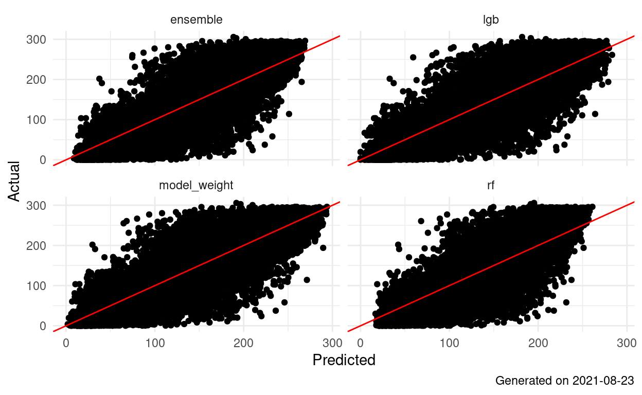
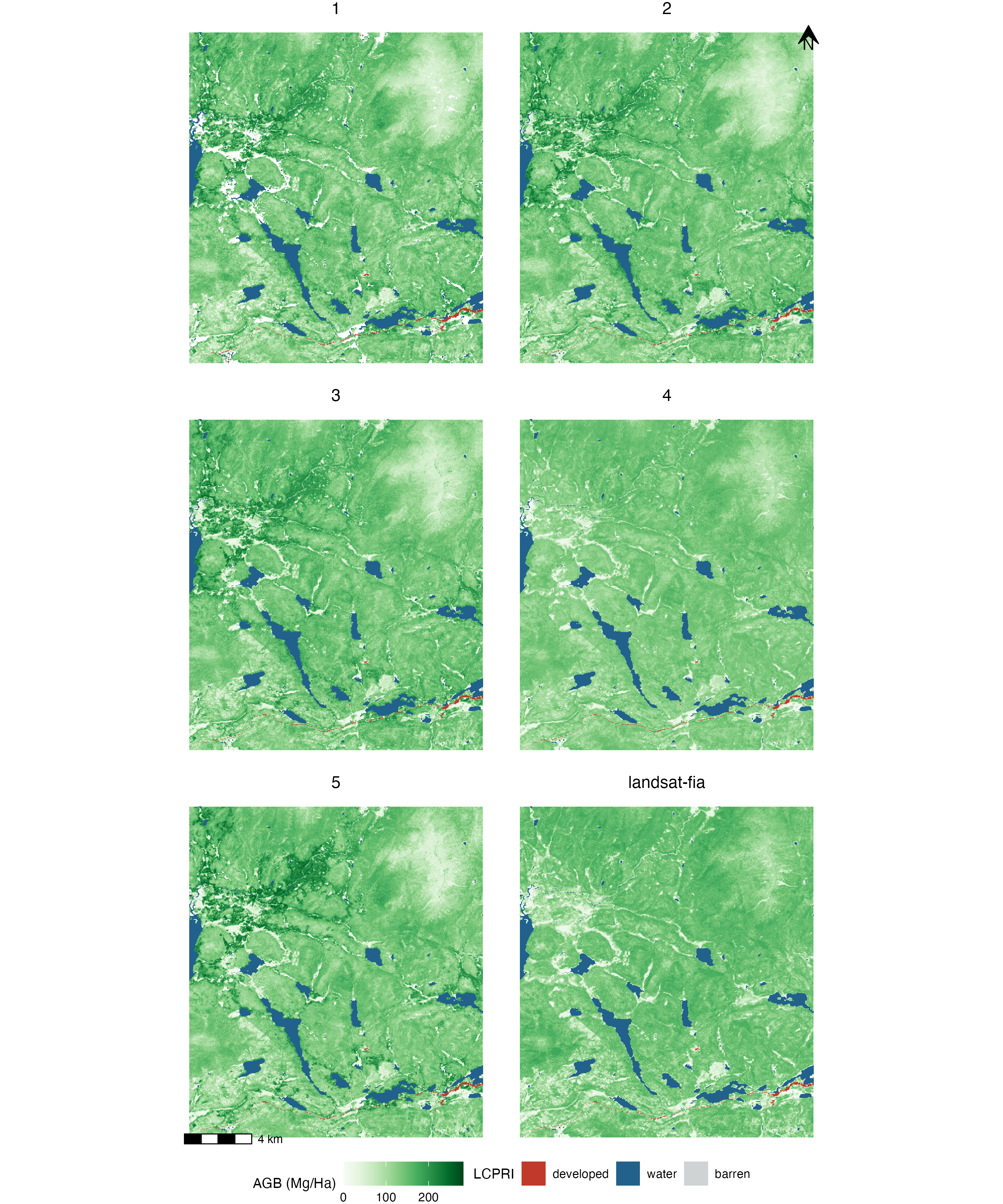
Landsat:LiDAR AGB 0.0.7: Forced 0s
Hudak-method models using LiDAR surfaces with LCMAP classes 1, 5, 8 forced to 0. 2021-08-23
Landsat:LiDAR-AGB v0.0.6 Map Accuracy
Map accuracy/agreement assessment following the Riemann et. al. framework.
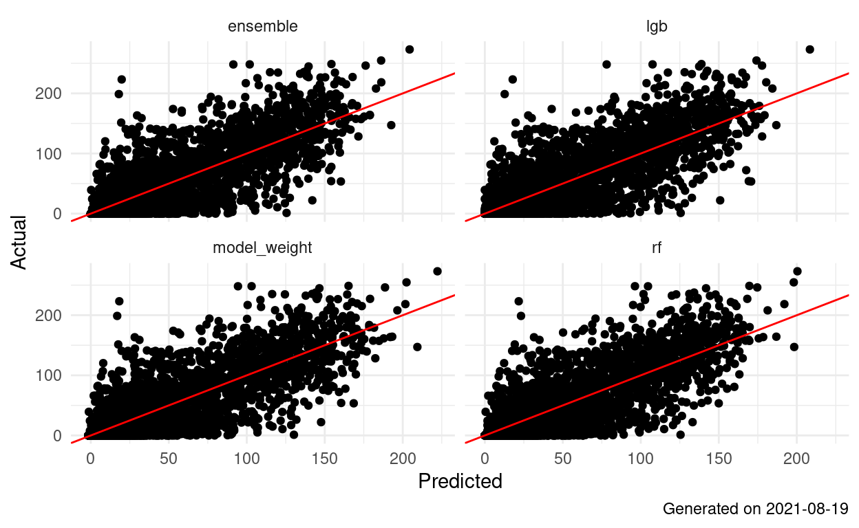
Landsat:Lidar AGB 0.0.6: LCMAP Stratification
Hudak-method models stratified by LCMAP and coverage area. 2021-08-19

1.2.0: This time it's LCMAP
Lidar-based models using LCMAP primary and secondary classes as predictors. 2021-08-05
Landsat:FIA v0.0.5 Map Accuracy - Holdout Plots Only
Map accuracy/agreement assessment following the Riemann et. al. framework.
Landsat:LiDAR-AGB v0.0.5 Map Accuracy - Holdout Plots Only
Map accuracy/agreement assessment following the Riemann et. al. framework.
Landsat:FIA v0.0.5 Map Accuracy
Map accuracy/agreement assessment following the Riemann et. al. framework.
Landsat:LiDAR-AGB v0.0.5 Map Accuracy
Map accuracy/agreement assessment following the Riemann et. al. framework.
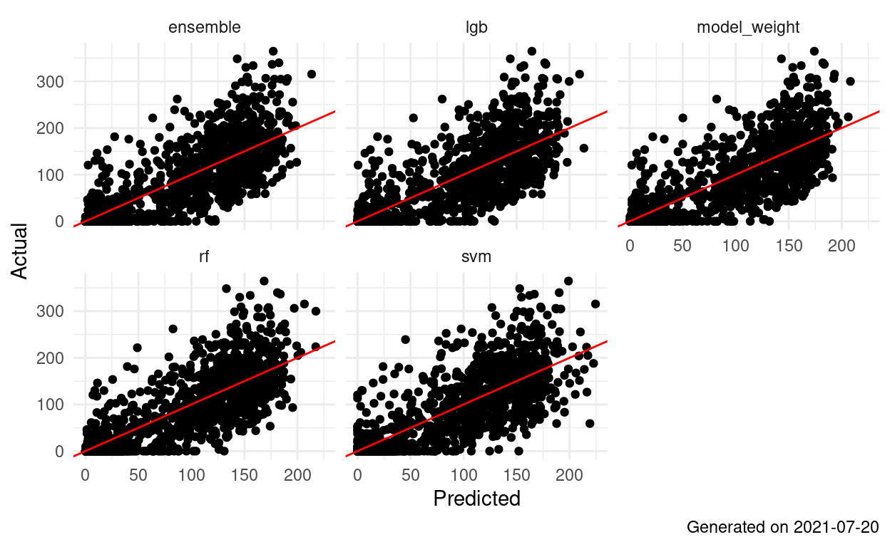
Landsat FIA AGB 0.0.5: High Class
Landsat AGB 0.0.5: High Class
Hudak-method models using LCMAP primary and secondary classifications as predictors. 2021-07-19
Landsat:FIA (Mask less) Map Accuracy
Map accuracy/agreement assessment following the Riemann et. al. framework.
Landsat:LiDAR-AGB v0.0.4 Map Accuracy
Map accuracy/agreement assessment following the Riemann et. al. framework.
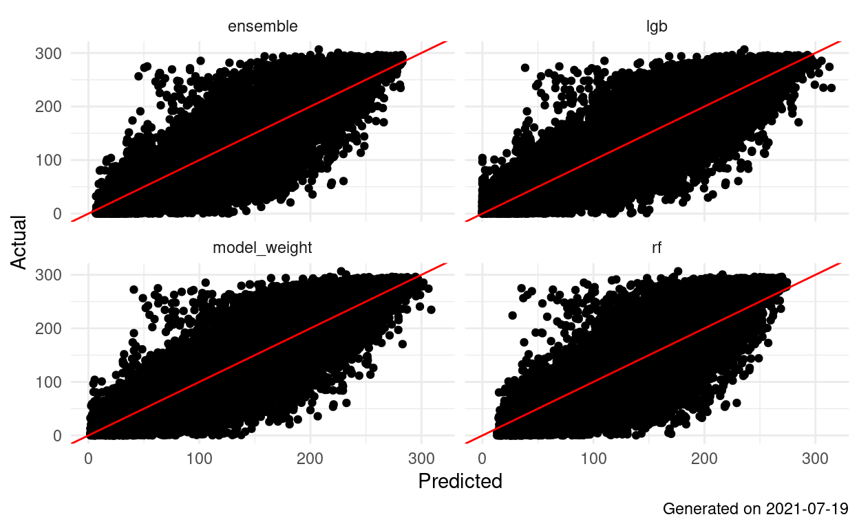
Landsat AGB 0.0.4: Do it Better
Landsat models actually built using 5 land cover types. Using 19 LiDAR coverages. 2021-07-13
Landsat:FIA Map Accuracy
Map accuracy/agreement assessment following the Riemann et. al. framework.
Landsat:LiDAR-AGB Map Accuracy
Map accuracy/agreement assessment following the Riemann et. al. framework.
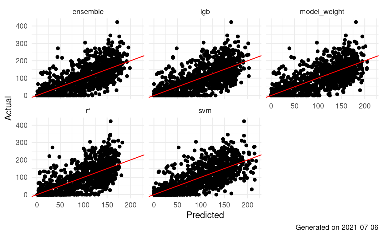
Landsat FIA AGB - Take Two
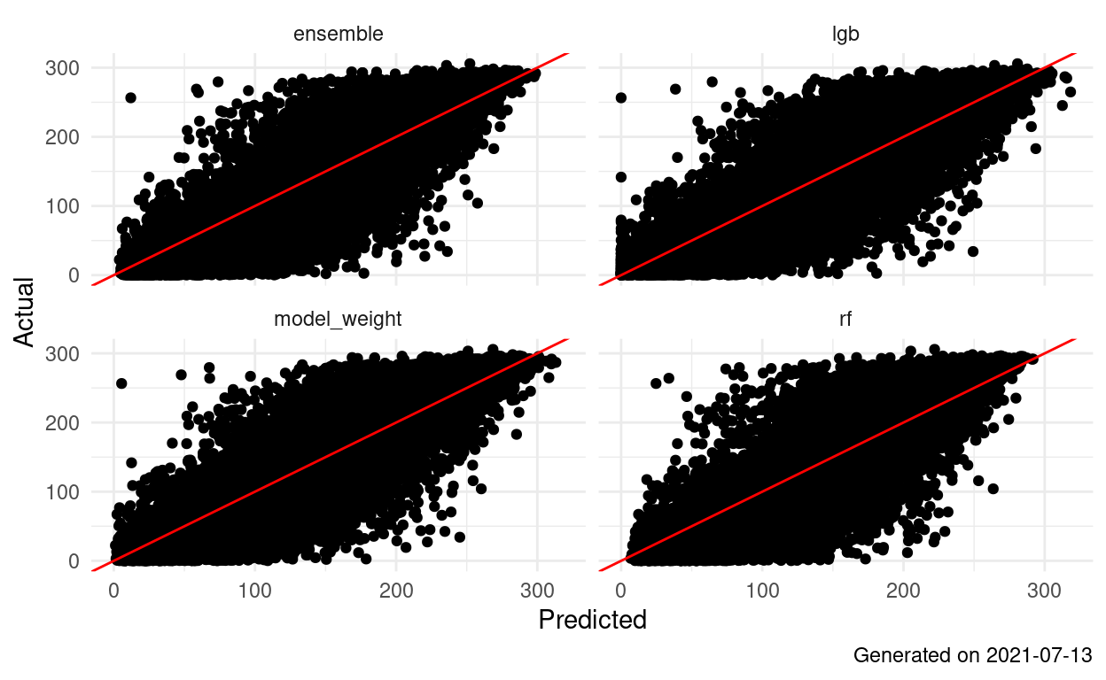
Landsat AGB 0.0.3: Big Tent
Landsat models built using 5 land cover types. Using 19 LiDAR coverages. 2021-07-03
Landsat AGB 0.0.2: Full Coverage Foundation
The basic landsat AGB models that we'll work on building up from. Using 19 LiDAR coverages. 2021-06-29
Landsat FIA AGB
Landsat AGB: Early Efforts

1.1.0: Overstory Only
Using only overstory measurements/removing understory plots from AGB. 2021-05-30
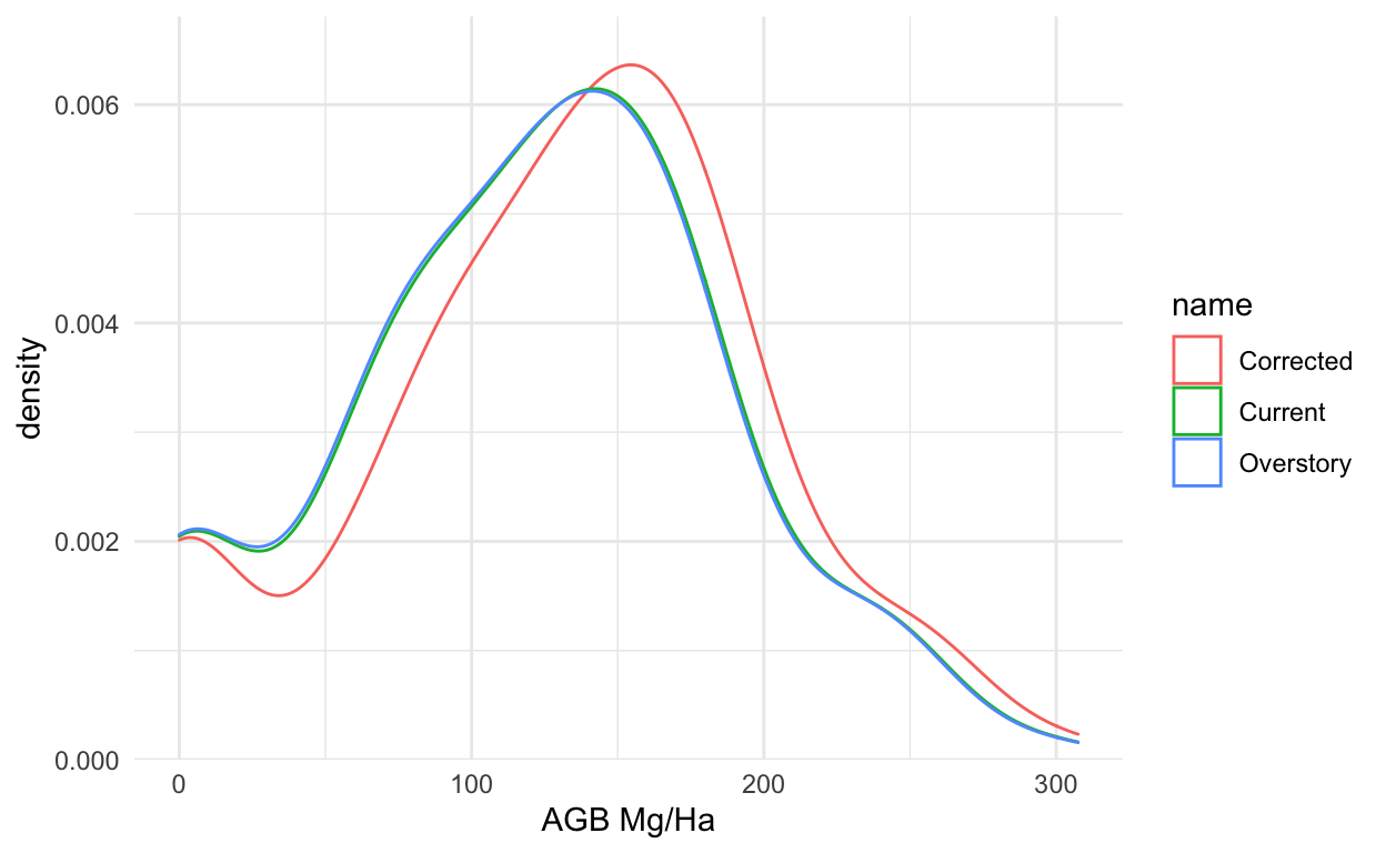
Plot-level AGB Comparisons; Understory and Overstory
Analysis of understory AGB impact on plot-level AGB distributions across pilot areas.
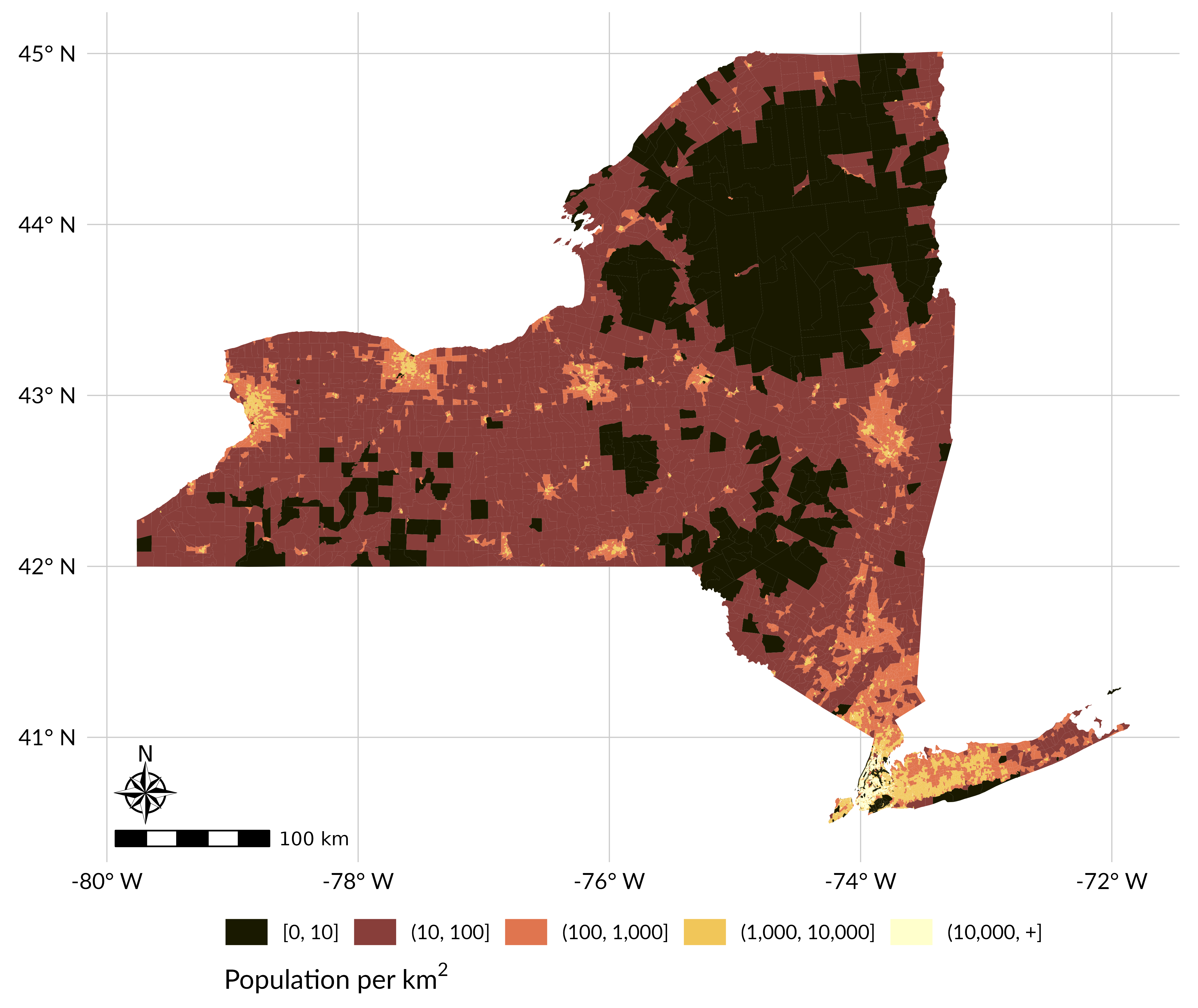
NYS AGB 1990-2019
Hudak style map products; Proof of concept for statewide mapping
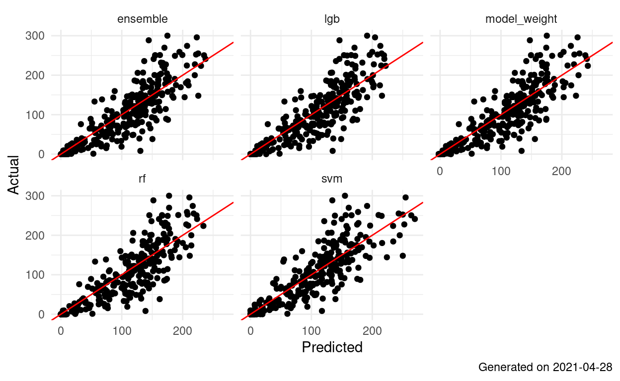
1.0.1: Big Tune and Then Some
Adding in those missing 29 plots to the same Big Tune recipe. 2021-05-13
Big Tune Map Accuracy v2 - Pooled+
Map accuracy/agreement assessment following the Riemann et. al. framework.
Big Tune Map Accuracy v2 - Testing+
Map accuracy/agreement assessment following Riemann et. al. framework.
Big Tune Map Accuracy v2 - Training
Map accuracy/agreement assessment following Riemann et. al. framework.
Post-Processed (2019) LiDAR-year AGB Surfaces
Displaying and quantifying updates to harmonize LiDAR-year AGB surfaces to the year 2019 using LCMAP Collection 1.1 data.
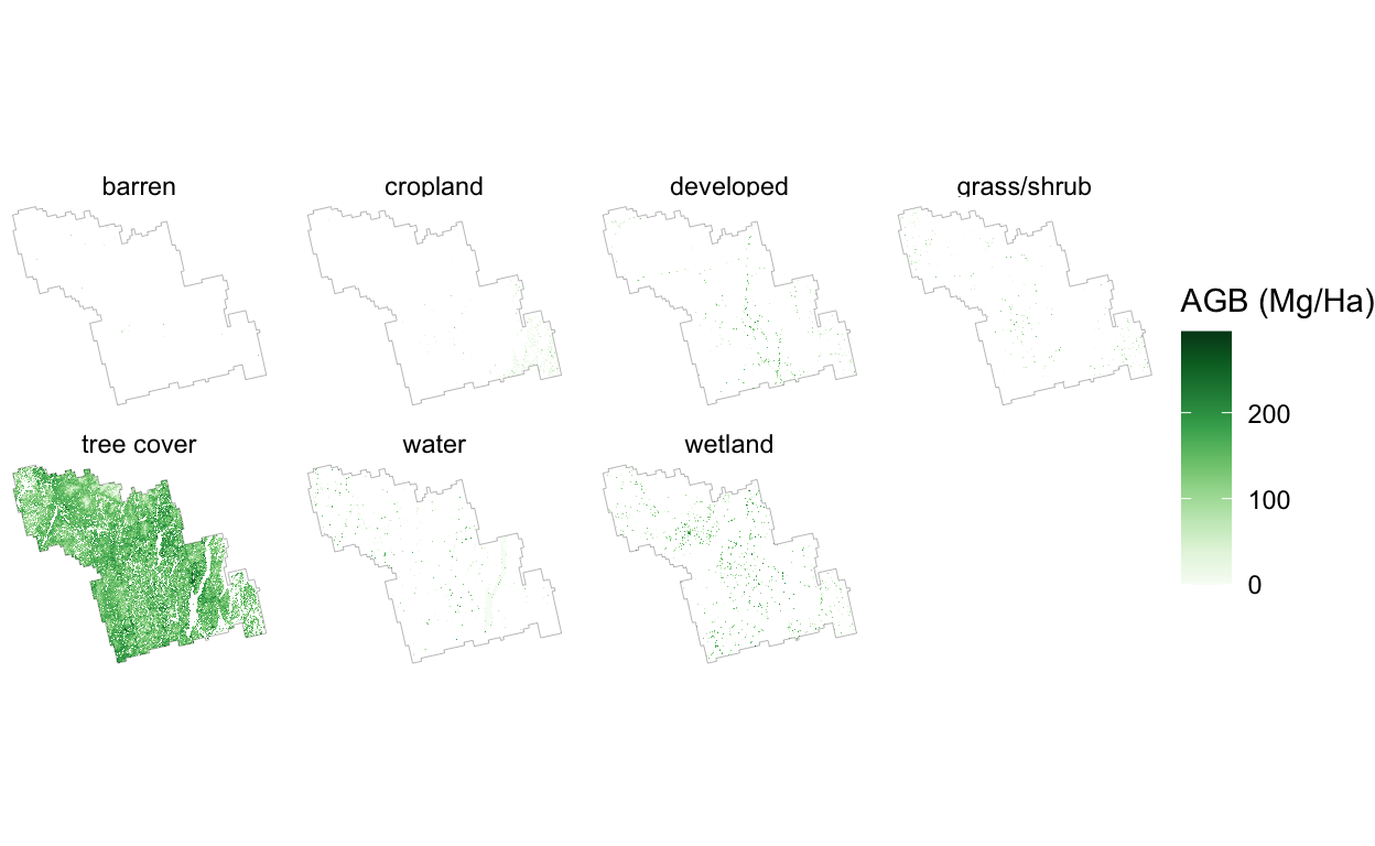
AGBxLandcover Tabulations
Quantifying AGB density across landcover classes/groups. The goal of this analysis is to help us understand how various masks (e.g many classes vs few) will impact AGB/C tabulations.
Component Bias Corrections
Holdout set accuracy for Component Bias Correction, 2021-04-26
Ensemble Bias Corrections
Holdout set accuracy for Ensemble Bias Corrections, 2021-04-26
Universal Bias Corrections
Holdout set accuracy for Universal Bias Corrections, 2021-04-26
Historical AGB Display
Hudak style map products
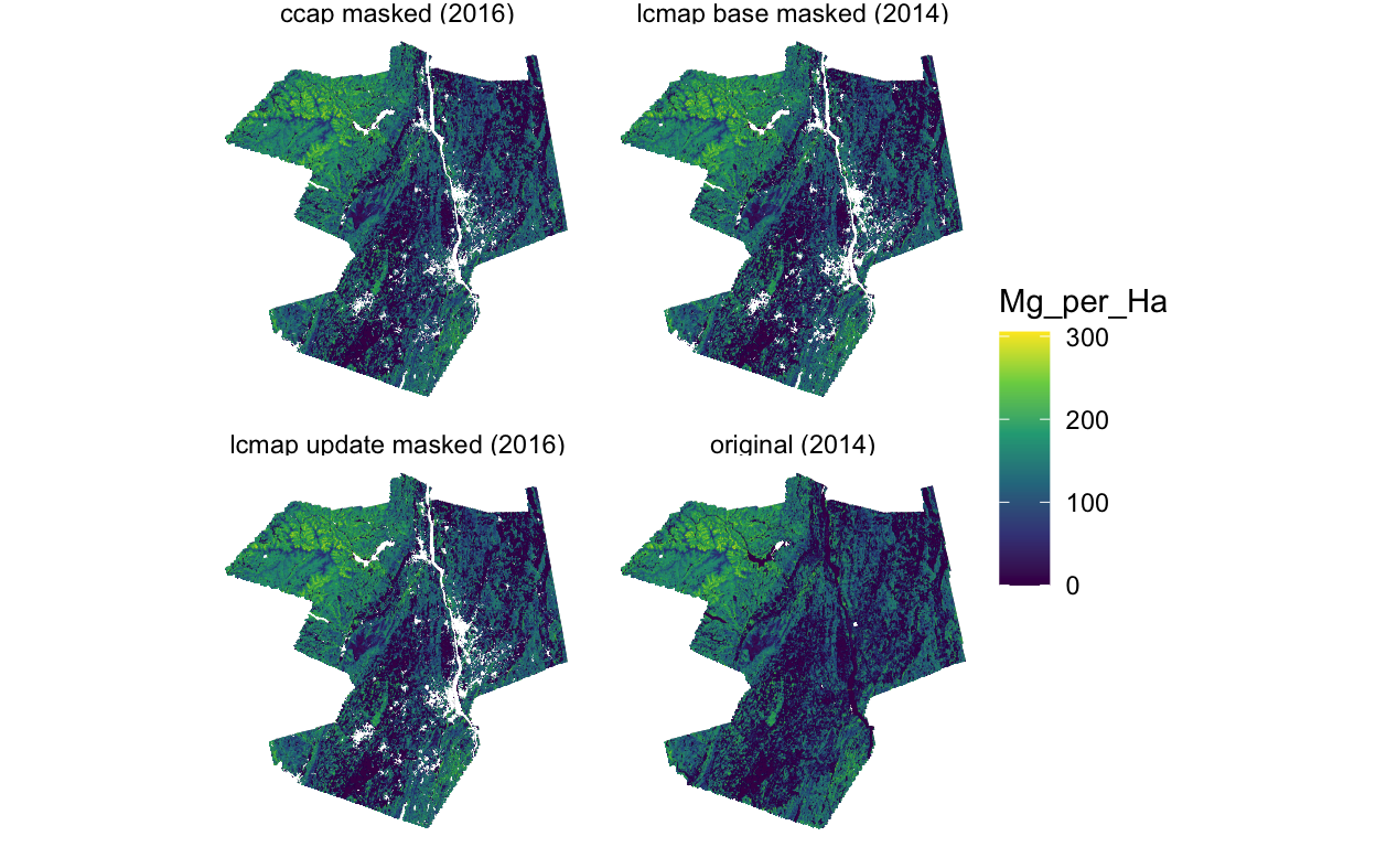
AGB Post-processing Results: USGS_3County2014
Applying landcover masks to USGS_3County2014 LiDAR-year AGB surface. Target Year: 2016 Model: linmod
Stripe Investigation
Link to WWE AGB stripe problem investigations.
Model Updates
Hudak POC Model – trained on WWE, with LCMAP (tree cover only) masking and stratified sampling
Big Tune Map Accuracy v1
Links to map accuracy documents for Big Tune.
Big Tune AGB
Links to AGB surfaces produced via Big Tune
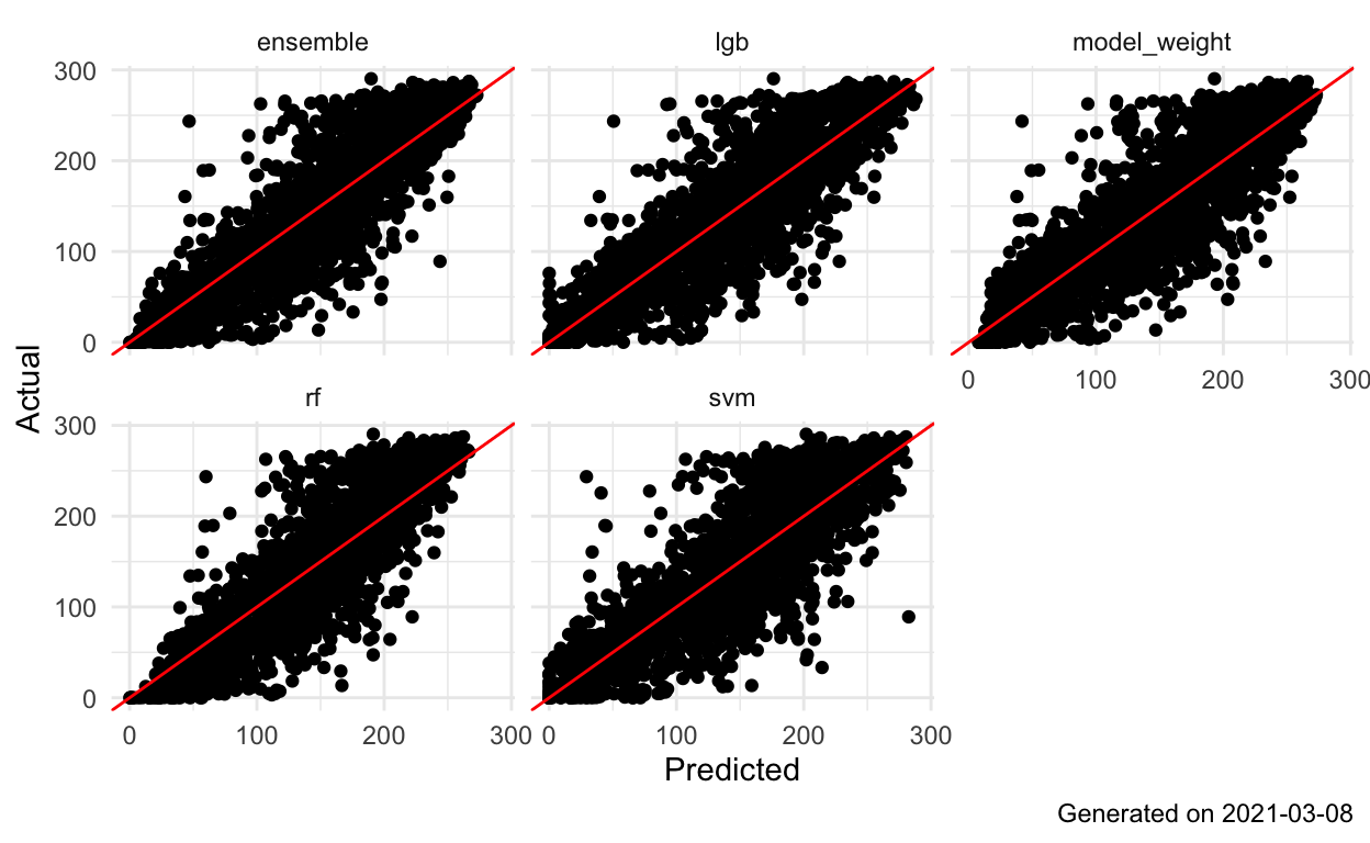
The Big Tune
Holdout set accuracy for the Big Tune, 2021-02-03